Romney, Indiana: Difference between revisions
Appearance
Content deleted Content added
Huwmanbeing (talk | contribs) |
m Add references section and/or general fixes. |
||
| Line 90: | Line 90: | ||
Romney is located at 40°15'5" North, 86°54'13" West (40.251426, -86.903618) in [[Randolph Township, Tippecanoe County, Indiana|Randolph Township]]. The town has an elevation of approximately 740 feet. |
Romney is located at 40°15'5" North, 86°54'13" West (40.251426, -86.903618) in [[Randolph Township, Tippecanoe County, Indiana|Randolph Township]]. The town has an elevation of approximately 740 feet. |
||
==References== |
|||
| ⚫ | |||
<references /> |
|||
| ⚫ | |||
{{Mapit-US-cityscale|40.2514260|-86.9036179}} |
{{Mapit-US-cityscale|40.2514260|-86.9036179}} |
||
[[Image:Romney, Indiana 1878.png|thumb|left|100px|Romney in 1878.]] |
[[Image:Romney, Indiana 1878.png|thumb|left|100px|Romney in 1878.]] |
||
| ⚫ | |||
[[Category:Tippecanoe County, Indiana]] |
[[Category:Tippecanoe County, Indiana]] |
||
| Line 102: | Line 107: | ||
[[vo:Romney (Indiana)]] |
[[vo:Romney (Indiana)]] |
||
| ⚫ | |||
Revision as of 06:37, 6 April 2008
Romney | |
|---|---|
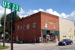
 Romney Toy Shop on Main Street | |
| Country | United States |
| State | Indiana |
| County | Tippecanoe |
| Township | Randolph |
| Elevation | 738 ft (225 m) |
| ZIP code | 47981 |
| GNIS feature ID | 0442271 |
Romney is an unincorporated community in Tippecanoe County in the U.S. state of Indiana. Originally named Columbia, Romney received its present name from the community of Romney in West Virginia.
Geography
Romney is located at 40°15'5" North, 86°54'13" West (40.251426, -86.903618) in Randolph Township. The town has an elevation of approximately 740 feet.
References
External links


