Beaverlodge: Difference between revisions
TheTwoRoads (talk | contribs) No edit summary |
TheTwoRoads (talk | contribs) No edit summary |
||
| Line 118: | Line 118: | ||
*land area of {{km2 to mi2|5.58|abbr=yes|wiki=yes}} ] |
*land area of {{km2 to mi2|5.58|abbr=yes|wiki=yes}} ] |
||
*and a [[population density]] of {{Pop density km2 to mi2|405.9| spell=UK | abbr=yes}}.<ref name=statcan2006>{{Cite web| url= http://www12.statcan.ca/english/census06/data/profiles/community/Details/Page.cfm?Lang=E&Geo1=CSD&Code1=4819009&Geo2=PR&Code2=48&Data=Count&SearchText=Beaverlodge&SearchType=Begins&SearchPR=01&B1=All&GeoLevel=&GeoCode=4819009 | title= Beaverlodge - Community Profile | author= Statistics Canada| authorlink= Statistics Canada| year= [[Canada 2006 Census|Census 2006]] | accessdate= 2007-06-09}}</ref> |
*and a [[population density]] of {{Pop density km2 to mi2|405.9| spell=UK | abbr=yes}}.<ref name=statcan2006>{{Cite web| url= http://www12.statcan.ca/english/census06/data/profiles/community/Details/Page.cfm?Lang=E&Geo1=CSD&Code1=4819009&Geo2=PR&Code2=48&Data=Count&SearchText=Beaverlodge&SearchType=Begins&SearchPR=01&B1=All&GeoLevel=&GeoCode=4819009 | title= Beaverlodge - Community Profile | author= Statistics Canada| authorlink= Statistics Canada| year= [[Canada 2006 Census|Census 2006]] | accessdate= 2007-06-09}}</ref> |
||
==History== |
|||
*Early [[1900]]'s: Settlers arrived in the the area via the Athabasca Trail and the Edson Trail and Hinton Trail. |
|||
*[[1909]]: The first store opened in the settlement. |
|||
*[[1910]]: The first post office is opened, and the settlement is named "Redwillow", refering to a nearby river. Later the name was changed to Beaverlodge, which came from the lodges all along the river built by the Beaver Indians. |
|||
*[[1910]]: The first school was build at the old townsite. Two more schools were opened shortly afterwards. |
|||
*[[1954]]: A [[Canadian Forces]] [[Radar]] Station is established east of Beaverlodge, creating traffic in the community until [[1988]], when the station was closed. |
|||
*[[2002]]: A new post office is opened. |
|||
==Ammenities== |
==Ammenities== |
||
Revision as of 22:34, 23 April 2008
Town of Beaverlodge | |
|---|---|
Town | |
 Highway 43 passing through Beaverlodge | |
 | |
| Country | |
| Province | |
| Region | Northern Alberta |
| Census division | 19 |
| County | Grande Prairie |
| Government | |
| • Governing body | Beaverlodge Town Council |
| Area | |
• Total | 5.58 km2 (2.15 sq mi) |
| Elevation | 732 m (2,402 ft) |
| Population (2006) | |
• Total | 2,264 |
| • Density | 405.9/km2 (1,051/sq mi) |
| Time zone | UTC-7 (MST) |
| Highways | Highway 43 |
| Waterways | Beaverlodge River |
| Website | Town of Beaverlodge |
Beaverlodge is a town in northern Alberta, Canada. It is located on Highway 43, Template:Km to mi west of Grande Prairie and Template:Km to mi east of the British Columbia border.

Demographics
According to the 2006 census, Beaverlodge has a:
- population of 2,264 living in 950 dwellings, a 7.3% increase from 2001
- land area of Template:Km2 to mi2 ]
- and a population density of Template:Pop density km2 to mi2.[1]
History
- Early 1900's: Settlers arrived in the the area via the Athabasca Trail and the Edson Trail and Hinton Trail.
- 1909: The first store opened in the settlement.
- 1910: The first post office is opened, and the settlement is named "Redwillow", refering to a nearby river. Later the name was changed to Beaverlodge, which came from the lodges all along the river built by the Beaver Indians.
- 1910: The first school was build at the old townsite. Two more schools were opened shortly afterwards.
- 1954: A Canadian Forces Radar Station is established east of Beaverlodge, creating traffic in the community until 1988, when the station was closed.
- 2002: A new post office is opened.
Ammenities
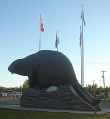
In 2004, a Giant Beaver statue was unveiled in the town's park, it can be seen from Highway 43.
The town has an arena, home of the Beaverlodge Blades (NWJHL), an outdoor swimming pool and a handful of newly refurbished play parks. There is an elementary school, grade K-6, Junior High students are bused to Hythe for grades 7-9, St.Mary's Catholic School is available for students attending grades 1-9. The high school, Beaverlodge Regional High School (BRHS) is attended by students from Wembley, Valhalla, Hythe, Horse Lake and Kelly Lake (Indian reservations), Elmworth and St.Mary's in addition to the local Beaverlodge students.
Beaverlodge is the birthplace of Matt Walker (hockey player).
See also
References
- ^ Statistics Canada (Census 2006). "Beaverlodge - Community Profile". Retrieved 2007-06-09.
{{cite web}}: Check date values in:|year=(help)CS1 maint: year (link)
External links
- Town of Beaverlodge
- Discover the Peace Country. Beaverlodge
55°12′34″N 119°25′45″W / 55.20944°N 119.42917°W
