Microregion of Porangatu: Difference between revisions
Appearance
Content deleted Content added
No edit summary |
|||
| Line 1: | Line 1: | ||
[[Image:Goias Micro Porangatu.svg|thumb|right| |
[[Image:Goias Micro Porangatu.svg|thumb|right|300px|]] |
||
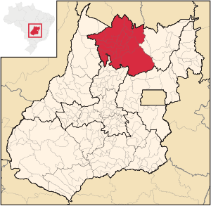
'''The Porangatu Microregion''' is a statistical region created by IBGE (Instituto Brasileiro de Geografia e Economia) in north-central [[Goiás]] state, [[Brazil]]. The most important city is [[Porangatu]]. For a map see [http://www.citybrazil.com.br/go/regioes/porangatu/ Citybrazil]. |
'''The Porangatu Microregion''' is a statistical region created by IBGE (Instituto Brasileiro de Geografia e Economia) in north-central [[Goiás]] state, [[Brazil]]. The most important city is [[Porangatu]]. For a map see [http://www.citybrazil.com.br/go/regioes/porangatu/ Citybrazil]. |
||
| Line 55: | Line 55: | ||
===See also=== |
===See also=== |
||
[[List of municipalities in Goiás]] |
*[[List of municipalities in Goiás]] |
||
*[[Microregions of Goiás]] |
|||
[[Category:Goiás]] |
[[Category:Goiás]] |
||
Revision as of 17:39, 28 April 2008

The Porangatu Microregion is a statistical region created by IBGE (Instituto Brasileiro de Geografia e Economia) in north-central Goiás state, Brazil. The most important city is Porangatu. For a map see Citybrazil.
Important Data (2007)
- Population 2000: 226,766
- Population 2007: 220,794
- Cities: 19
- Total Area: 35,287.40 km²
- Population Density 2007: 6.26 inhab/km²
In area this microregion is smaller than Taiwan and larger than Moldova.
Cities in the Porangatu Microregion
- Alto Horizonte
- Amaralina
- Bonópolis
- Campinaçu
- Campinorte
- Campos Verdes
- Estrela do Norte
- Formoso
- Mara Rosa
- Minaçu
- Montividiu do Norte
- Mutunópolis
- Niquelândia (the largest municipality in the state in land area)
- Nova Iguaçu de Goiás
- Porangatu (large herds of cattle)
- Santa Tereza de Goiás
- Santa Terezinha de Goiás
- Trombas
- Uruaçu
List of microregions in Goiás
- Anápolis
- Anicuns
- Aragarças
- Catalão
- Ceres
- Chapada dos Veadeiros
- Entorno de Brasília
- Goiânia
- Iporá
- Meia Ponte
- Pires do Rio
- Porangatu
- Quirinópolis
- Rio Vermelho
- São Miguel do Araguaia
- Sudoeste de Goiás
- Vale do Rio dos Bois
- Vão do Paranã
