Landsmeer: Difference between revisions
Appearance
Content deleted Content added
No edit summary |
RoboServien (talk | contribs) m robot Adding: nds-nl:Laansmeer |
||
| Line 79: | Line 79: | ||
[[li:Landsmeer]] |
[[li:Landsmeer]] |
||
[[nl:Landsmeer]] |
[[nl:Landsmeer]] |
||
[[nds-nl:Laansmeer]] |
|||
[[sv:Landsmeer]] |
[[sv:Landsmeer]] |
||
[[vo:Landsmeer]] |
[[vo:Landsmeer]] |
||
Revision as of 15:46, 27 June 2008
Landsmeer | |
|---|---|
Municipality | |
 | |
| Country | Netherlands |
| Province | North Holland |
| Government | |
| Area (2006) | |
• Total | 26.49 km2 (10.23 sq mi) |
| • Land | 22.54 km2 (8.70 sq mi) |
| • Water | 3.95 km2 (1.53 sq mi) |
| Population | |
• Total | 10,271 |
| • Density | 456/km2 (1,180/sq mi) |
| Source: CBS, Statline. | |
| Time zone | UTC+1 (CET) |
| • Summer (DST) | UTC+2 (CEST) |
| Website | www.landsmeer.nl |
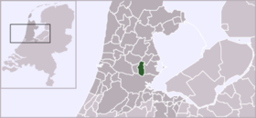
![]() Landsmeer is a municipality and a town in the Netherlands, in the province of North Holland.
Landsmeer is a municipality and a town in the Netherlands, in the province of North Holland.
Population centres
The municipality of Landsmeer consists of the following cities, towns, villages and/or districts: Den Ilp, Landsmeer, Purmerland.
Local government
The municipal council of Landsmeer consists of 15 seats, which are divided as follows:
- PvdA - 5 seats
- VVD - 4 seats
- Gemeente Belangen - 2 seats
- CDA - 1 seats
- D66 - 1 seat
- GroenLinks - 1 seat
- PVL - 1 seat
Town twinning
Landsmeer is twinned with the following towns:
 Bergneustadt since 1968
 Châtenay-Malabry, Hauts-de-Seine, since 1986
- Bergneustadt and Châtenay-Malabry are twinned since 1967
References
- Statistics are taken from the SDU Staatscourant


