Kyrkheddinge: Difference between revisions
Appearance
Content deleted Content added
No edit summary |
m fmt coor |
||
| Line 30: | Line 30: | ||
{{Reflist}} |
{{Reflist}} |
||
{{ |
{{coord|55|39|N|13|16|E|region:SE_type:city|display=title}} |
||
'''Kyrkheddinge''' is a [[urban areas in Sweden|locality]] in [[Staffanstorp Municipality]], [[Skåne County]] in southern [[Sweden]]. Kyrkheddinge has a population of 251 inhabitants (2005). |
'''Kyrkheddinge''' is a [[urban areas in Sweden|locality]] in [[Staffanstorp Municipality]], [[Skåne County]] in southern [[Sweden]]. Kyrkheddinge has a population of 251 inhabitants (2005). |
||
Revision as of 18:09, 28 September 2008
Kyrkheddinge | |
|---|---|
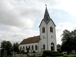
 Church (Kyrka) in Kyrkheddinge. | |
 | |
| Country | Sweden |
| Municipality | Staffanstorp Municipality |
| County | Skåne County |
| Province | Skåne |
| Population (2005-12-31) | |
• Total | 251 |
| Time zone | UTC+1 (CET) |
| • Summer (DST) | UTC+2 (CEST) |
References
Wikimedia Commons has media related to Kyrkheddinge.
55°39′N 13°16′E / 55.650°N 13.267°E
Kyrkheddinge is a locality in Staffanstorp Municipality, Skåne County in southern Sweden. Kyrkheddinge has a population of 251 inhabitants (2005).
It is situated about 9 km southeast of Lund and 6 km west-southwest of Dalby.
