Toggenburg: Difference between revisions
m Quick-adding category "1468 disestablishments" (using HotCat) |
m Quick-adding category "10th-century establishments" (using HotCat) |
||
| Line 75: | Line 75: | ||
[[Category:Rhine basin]] |
[[Category:Rhine basin]] |
||
[[Category:1468 disestablishments]] |
[[Category:1468 disestablishments]] |
||
[[Category:10th-century establishments]] |
|||
[[als:Toggenburg]] |
[[als:Toggenburg]] |
||
Revision as of 07:30, 7 February 2009
County of Toggenburg Grafschaft Toggenburg | |||||||
|---|---|---|---|---|---|---|---|
| 10th century–1468 | |||||||
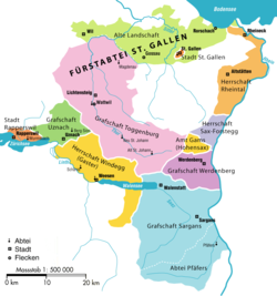
 The old Bestandteile of the Canton of St. Gall, showing the County of Toggenburg in pink. | |||||||
| Status | State of the Holy Roman Empire | ||||||
| Capital | Lichtensteig | ||||||
| Government | Principality | ||||||
| Historical era | Middle Ages | ||||||
• Established | before 1044 10th century | ||||||
• Partitioned | 1394 | ||||||
• Comital line extinct | 1436 | ||||||
• Old Zürich War | 1440–46 | ||||||
• Inherited by Raron | Uncertain | ||||||
• Sold to the Abbot of St Gall | 1468 | ||||||
| |||||||

Toggenburg is the name given to the upper valley of the river Thur, in the Swiss Canton of St. Gallen. Currently, it is one of the eight constituencies into which the canton is divided.
The valley descends in a northwestern direction from the watershed between the Rhine and the Thur, and is enclosed on the northeast by the chain of the Säntis (8216 ft) and on the southwest by that of the Churfirsten (7576 ft) and of the Speer (6411 ft). It is a fertile valley of about 45 kilometers in length from the source of the river to Wil on the railway line between Winterthur and St. Gallen. The upper half is traversed by an excellent road, while from Nesslau there is a railway to Wil (155 m).
At Wildhaus, the highest village (3632 ft), the house wherein Huldrych Zwingli, the Swiss Reformer, was born in 1484, is still shown. Other villages are Lichtensteig, Kirchberg and Wattwil.
The extinction of the main line of the counts of Toggenburg (1436) led to the Old Zürich War (1440–46) ultimately resulting in the temporary expulsion of Zürich from the Swiss confederacy. Eventually, the Toggenburg passed to the lord of Raron (in Valais), who sold it in 1468 to the abbot of St. Gall.
Part of the Toggenburg followed the Swiss Reformation led by Zwingli, and the valley declared itself independent in 1530, but was forced to re-submit to the Abbot of St. Gall in 1538. The Abbot was, however, pressured into toleration of either confession, so that the Toggenburg became one of the few regions of Switzerland where Catholicism and Protestantism have a tradition of co-existence.
In 1707, the Toggenburg again declared its independence of St. Gall, in reaction to the Abbey's plans to build a road across the Ricken, which was seen as a strategic arrangement towards a Catholic military alliance. The ensuing Toggenburg war of 1712 resulted in a balance of power between Catholic and Protestant cantons, ultimately leading to the formation of Switzerland as a federal state.
In the Helvetic Republic, the Toggenburg was divided between the cantons of Säntis and Linth. The parts were re-united as part of the canton of St. Gallen in 1803.
Gallery
-
The 7 Churfirsten (view from Alpstein with Toggenburg below)
-
Toggenburg (view from castle Iberg in Wattwil)
References
- This article incorporates text from a publication now in the public domain: Chisholm, Hugh, ed. (1911). Encyclopædia Britannica (11th ed.). Cambridge University Press.
{{cite encyclopedia}}: Missing or empty|title=(help)
External links
- http://www.toggenburg.org/en/welcome.cfm? tourist information in English
- http://www.toggenburg.org tourist information in German


