Turbenthal: Difference between revisions
Appearance
Content deleted Content added
m →External links: {{commonscat}} |
Added coat of arms |
||
| Line 3: | Line 3: | ||
| municipality_name = Turbenthal |
| municipality_name = Turbenthal |
||
| municipality_type = municipality |
| municipality_type = municipality |
||
| imagepath_coa = |pixel_coa= |
| imagepath_coa = Turbenthal.svg|pixel_coa= |
||
| map = |
| map = |
||
| languages = German |
| languages = German |
||
Revision as of 12:06, 17 April 2009
Turbenthal | |
|---|---|
| Country | Switzerland |
| Canton | Zurich |
| District | Winterthur |
| Area | |
• Total | 25.07 km2 (9.68 sq mi) |
| Elevation | 554 m (1,818 ft) |
| Population (31 December 2018)[2] | |
• Total | 4,899 |
| • Density | 200/km2 (510/sq mi) |
| Time zone | UTC+01:00 (Central European Time) |
| • Summer (DST) | UTC+02:00 (Central European Summer Time) |
| Postal code(s) | 8488 |
| SFOS number | 0228 |
| ISO 3166 code | CH-ZH |
| Surrounded by | Aadorf (TG), Bichelsee-Balterswil (TG), Fischingen (TG), Hofstetten bei Elgg, Schlatt, Wila, Wildberg, Zell |
| Website | www SFSO statistics |
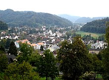
Turbenthal is a municipality in the district of Winterthur in the canton of Zürich in Switzerland.


External links
Wikimedia Commons has media related to Turbenthal.
- ^ a b "Arealstatistik Standard - Gemeinden nach 4 Hauptbereichen". Federal Statistical Office. Retrieved 13 January 2019.
- ^ "Ständige Wohnbevölkerung nach Staatsangehörigkeitskategorie Geschlecht und Gemeinde; Provisorische Jahresergebnisse; 2018". Federal Statistical Office. 9 April 2019. Retrieved 11 April 2019.


