Rangamati: Difference between revisions
Souvik.arko (talk | contribs) |
Souvik.arko (talk | contribs) No edit summary |
||
| Line 5: | Line 5: | ||
|official_name = Rangamati |
|official_name = Rangamati |
||
|other_name = |
|other_name = |
||
|native_name = Ramytte |
|native_name = Ramytte |
||
|nickname = |
|nickname = |
||
|settlement_type = <!--For Town or Village (Leave blank for the default City)--> |
|settlement_type = <!--For Town or Village (Leave blank for the default City)--> |
||
| Line 125: | Line 125: | ||
}} |
}} |
||
[[File:Kapatailake.jpg|thumb|left|260px|Kaptai Lake |
[[File:Kapatailake.jpg|thumb|left|260px|Kaptai Lake]] |
||
'''Rangamati''' is the headquarter of [[Rangamati District]] in the [[Chittagong Hill Tracts]] of [[Bangladesh]]. The town is located at 22°37'60N 92°12'0E and has an altitude of 14 metres (49 feet).<ref>[http://www.fallingrain.com/world/BG/0/Rangamati.html Location of Rangamati - Falling Rain Genomics]</ref> |
'''Rangamati''' is the headquarter of [[Rangamati District]] in the [[Chittagong Hill Tracts]] of [[Bangladesh]]. The town is located at 22°37'60N 92°12'0E and has an altitude of 14 metres (49 feet).<ref>[http://www.fallingrain.com/world/BG/0/Rangamati.html Location of Rangamati - Falling Rain Genomics]</ref> |
||
It's a travel destination of Bangladesh which is known as "Lake City". |
It's a travel destination of Bangladesh which is known as "Lake City". |
||
From Chittagong a 77 km road amidst green fields and winding hills will take you to Rangamati, the headquarter of Rangamati Hill District which is a wonderful repository of scenic splendours with flora and fauna of varied descriptions. The township is located on the western bank of the Kaptai lake. Rangamati is a favourite holiday destination because of its beautiful landscape, scenic beauty, lake, colourful tribes (Chakma, Marma etc), its flora and fauna, tribal museum, hanging bridge, homespun textile products, ivory jewellery and the tribal men and women who fashion them. For tourists, the attractions of Rangamati are numerous. Tribal life, fishing, speed boat cruising |
From Chittagong a 77 km road amidst green fields and winding hills will take you to Rangamati, the headquarter of Rangamati Hill District which is a wonderful repository of scenic splendours with flora and fauna of varied descriptions. The township is located on the western bank of the Kaptai lake. Rangamati is a favourite holiday destination because of its beautiful landscape, scenic beauty, lake, colourful tribes (Chakma, Marma etc), its flora and fauna, tribal museum, hanging bridge, homespun textile products, ivory jewellery and the tribal men and women who fashion them. For tourists, the attractions of Rangamati are numerous. Tribal life, fishing, speed boat cruising, hiking, bathing or merely enjoying nature as it is. |
||
Revision as of 10:27, 15 September 2009
- This article is about the city. For the district, see Rangamati District and Rangamati (2008 film).
Rangamati
Ramytte | |
|---|---|
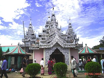
 Rajban Vihara(Buddhist Monastery), Rangamati | |
| Country | |
| Division | Chittagong Division |
| District | Rangamati District |
| Government | |
| • Pouroshava Mayor | Habibur Rahman |
| • Chakma Raja (Chakma Circle Chief) | Raja Debashish Roy |
| Elevation | 49 ft (14 m) |
| Time zone | UTC+6 (BST) |
| • Summer (DST) | UTC+7 (BDST) |
| Postal Code | 4500 |
| Area code | 0351 |

Rangamati is the headquarter of Rangamati District in the Chittagong Hill Tracts of Bangladesh. The town is located at 22°37'60N 92°12'0E and has an altitude of 14 metres (49 feet).[1]
It's a travel destination of Bangladesh which is known as "Lake City".
From Chittagong a 77 km road amidst green fields and winding hills will take you to Rangamati, the headquarter of Rangamati Hill District which is a wonderful repository of scenic splendours with flora and fauna of varied descriptions. The township is located on the western bank of the Kaptai lake. Rangamati is a favourite holiday destination because of its beautiful landscape, scenic beauty, lake, colourful tribes (Chakma, Marma etc), its flora and fauna, tribal museum, hanging bridge, homespun textile products, ivory jewellery and the tribal men and women who fashion them. For tourists, the attractions of Rangamati are numerous. Tribal life, fishing, speed boat cruising, hiking, bathing or merely enjoying nature as it is.
Notable landmarks


Hanging Bridge: Hanging Bridge(Jhulonto Bridge in Bengali)is the landmark icon of Rangamati. It's a popular tourist spot and a must go destination.
Kaptai Lake : Kaptai lake is a wonderful spot for boating and cruising. It's also known as Shubhalang. Parjatan and private tour operators offer a number of cruises by mechanical boats. One can go to various scenic spots in Shuvalong, Barkal, Longadu, Mainimukh and other areas by boat from Rangamati.
Tribal Museum : The only Tribal Cultural Museum in the Chittagong Hill Tracts region was established at Rangamati town in 1978 and run by the Tribal Cultural Institute. It preserves valuable objects and articles of different tribes depicting their socio-economic, cultural and historical tradition. These include typical tribal dresses, ornaments, arms and ammunitions, coins, statues made of wood, bronze and other metals, musical instruments, ivory products, handicrafts, paintings on tribal life etc.
Open: Saturday- Thursday, 10.00 a.m.- 4.00 p.m. Closed: Friday & Public Holidys. Admission is free.


