Augustinusga: Difference between revisions
Appearance
Content deleted Content added
m clean up |
|||
| Line 16: | Line 16: | ||
'''Augustinusga''' ({{lang-fry|Stynsgea}}) is a village in the municipality of [[Achtkarspelen]], [[Friesland]] province, The [[Netherlands]]. |
'''Augustinusga''' ({{lang-fry|Stynsgea}}) is a village in the municipality of [[Achtkarspelen]], [[Friesland]] province, The [[Netherlands]]. |
||
Augustinusga lies in the eastern part of the province of Friesland, 10 |
Augustinusga lies in the eastern part of the province of Friesland, 10 km north of [[Drachten]]. As of 1 January 2006, there was a population of 1,346. |
||
[[Category:Cities, towns and villages in Friesland]] |
[[Category:Cities, towns and villages in Friesland]] |
||
[[Category:Articles lacking sources (Erik9bot)]] |
[[Category:Articles lacking sources (Erik9bot)]] |
||
{{Friesland-geo-stub}} |
{{Friesland-geo-stub}} |
||
Revision as of 20:19, 12 October 2009
Augustinusga | |
|---|---|
Village | |
 | |
| Country | |
| Province | |
| Population | |
• Total | c. 1,350 |
53°13′N 6°10′E / 53.217°N 6.167°E
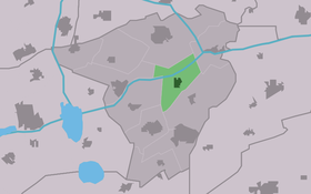
Augustinusga (Template:Lang-fry) is a village in the municipality of Achtkarspelen, Friesland province, The Netherlands.
Augustinusga lies in the eastern part of the province of Friesland, 10 km north of Drachten. As of 1 January 2006, there was a population of 1,346.

