Uithuizermeeden: Difference between revisions
Appearance
Content deleted Content added
m Translate parameter names from Dutch to English and clean up using AWB |
m clean up |
||
| Line 13: | Line 13: | ||
|website = |
|website = |
||
|image_shield = |
|image_shield = |
||
|latNS = N |
|||
|longEW = E |
|||
|latd = 53 |
|latd = 53 |
||
|latm = 24 |
|latm = 24 |
||
|lats = 52 |
|lats = 52 |
||
| |
|longd = 6 |
||
| |
|longm = 43 |
||
| |
|longs = 35 |
||
|image = [[File:Zicht op Uithuizermeeden met Mariakerk.jpg|260px]] |
|image = [[File:Zicht op Uithuizermeeden met Mariakerk.jpg|260px]] |
||
}} |
}} |
||
Revision as of 20:58, 12 October 2009
Uithuizermeeden | |
|---|---|
 | |
| Country | Netherlands |
| Province | Groningen (province) |
| Municipality | Eemsmond |
| Population (2008) | 2,790 |

Uithuizermeeden is a small village in the Netherlands, with a population of about 3200 people. It is part of the municipality of Eemsmond, close to the Wadden Sea.

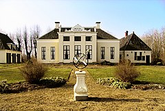
The most important points are the Meister Toren and the Rensumaborg (dated 1700, not open for public). The Meister Toren dated from the thirteenth century, but was rebuilt at the end of the 19th century in original style, after a fire destroyed it.
Uithuizermeeden has a population of more than 3200 people.
Uithuizermeeden was a separate municipality until 1979, when it became part of Hefshuizen.[1]
Wikimedia Commons has media related to Uithuizermeeden.
References
External links
53°25′N 6°44′E / 53.417°N 6.733°E

