Macclesfield Bank: Difference between revisions
No edit summary |
|||
| Line 21: | Line 21: | ||
| highest mount = unnamed point below sea level |
| highest mount = unnamed point below sea level |
||
| elevation = {{convert|-9.2|m|ft}} |
| elevation = {{convert|-9.2|m|ft}} |
||
| country claim |
| country claim = Philippines |
||
| country claim divisions title = |
| country claim divisions title = [[Province of the Philippines|Province]] |
||
| country claim divisions = |
| country claim divisions = [[Zambales]] |
||
| country 1 claim |
| country 1 claim = People's Republic of China |
||
| country 1 claim divisions title = |
| country 1 claim divisions title = [[County (China)|County]] |
||
| country 1 claim divisions = |
| country 1 claim divisions = [[Paracels, Spratlys, and Zhongsha Islands Authority]], [[Hainan]] |
||
| country 2 claim |
| country 2 claim = Taiwan |
||
| country 2 claim divisions title |
| country 2 claim divisions title = |
||
| country 2 claim divisions |
| country 2 claim divisions = |
||
| country |
| country = Philippines |
||
| population = none |
| population = none |
||
| population as of = |
| population as of = |
||
Revision as of 17:27, 17 October 2009
 | |
| Other names | Zhongsha Islands 中沙群島 Zhongsha Qundao Quần đảo Trung Sa Central Sand Islands |
|---|---|
| Geography | |
| Location | South China Sea |
| Coordinates | 16°00′N 114°30′E / 16.000°N 114.500°E |
| Administration | |
Philippines | |
| Demographics | |
| Population | none |

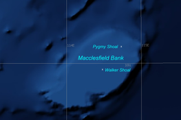
Macclesfield Bank or Zhongsha Islands (Chinese 中沙群島 Pinyin: Zhongsha Qundao; Template:Lang-vi, literally Central Sand Islands) is an elongated sunken atoll of underwater reefs and shoals in South China Sea and part of the disputed South China Sea Islands, centered around 16°00′N 114°30′E / 16.000°N 114.500°E, east of the Paracel Islands. Its length exceeds 130 km (81 mi) southwest-northeast, with a maximal width of more than 70 km (43 mi). With an area of 6,448 km2 (2,490 sq mi) within the outer rim of the reef[1], although completely submerged without any emergent cays or islets, it is one of the largest atolls of the world.
The broken coral reef rim of Macclesfield Bank, with a width of up to 8 km (5 mi), has depths of 11.8 m (39 ft) at Pygmy Shoal on the northeast end of the bank and depths of 11.6 to 18 m (59 ft) elsewhere. Within the lagoon, Walker Shoal marks the least known depth of 9.2 meters. In general, the central lagoon is very deep, with depths up to 100 meters [2].
Macclesfield Bank is claimed by the People's Republic of China , Republic of China (Taiwan) and Philippines. It is located east of the Paracel Islands, distantly southwest of the Pratas Islands and north of the Spratly Islands.
There are no military stations there. It is a rich fishing ground and difficult to navigate due to the shallow submerged reefs.
The elongated atoll consists of:
The Chinese term for the Macclesfield Bank has a wider meaning than the geographic feature or atoll; it includes some geographically separate features:
To the east, near the Philippines are
- Scarborough Shoal (Panatag Shoal), (Nanyan Dao, Huangyan Dao), 南巖島, 黃岩島, 15°11′N 117°46′E / 15.183°N 117.767°E), is occupied by the Philippines
- Truro Shoal (Sianfa Ansha, Shianfa Ansha, 特魯暗沙, 16°20′N 116°44′E / 16.333°N 116.733°E)
Far to the north is
- Helen Shoal (Itung Ansha, Yitong Ansha, 一統暗沙, 19°12′N 113°53′E / 19.200°N 113.883°E) is only a few kilometers south of Hong Kong


