Betania, Antioquia: Difference between revisions
Appearance
Content deleted Content added
m robot Adding: nl:Betania |
seal |
||
| Line 9: | Line 9: | ||
|image_caption = |
|image_caption = |
||
|image_flag = Banderabetania.svg |
|image_flag = Banderabetania.svg |
||
|image_seal = |
|image_seal = Escudo de Betania (Antioquia).svg |
||
|image_map = MunsAntioquia Betania.png |
|image_map = MunsAntioquia Betania.png |
||
|mapsize = 250px |
|mapsize = 250px |
||
Revision as of 02:13, 21 October 2009
Betania | |
|---|---|
Municipality and town | |
|
Flag of Betania Flag | |
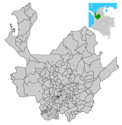
 Location of the municipality and town of Betania in the Antioquia Department of Colombia | |
| Country | |
| Department | Antioquia Department |
| Area | |
• Total | 168 km2 (65 sq mi) |
| Population (2002) | |
• Total | 11,133 |
| Time zone | UTC-5 (Colombia Standard Time) |
Betania (pronounced: Bai-TAHN-ee-uh) is a town and municipality in the Colombian department of Antioquia. Part of the subregion of Southwestern Antioquia. It exists 33 mi/53 km SW of Medellin. Main industries include coffee, sugarcane, cacao, and livestock.
A small village named Betania also exists in the town of Cua, located in Miranda State, Venezuela. It is popularly known for the shrine of Our Lady of Betania, where retired Catholic Bishop Pio Bello Ricardo declared authentic a Eucharistic Miracle that occurred there.
5°45′N 75°58′W / 5.750°N 75.967°W

