Montfoort: Difference between revisions
Appearance
Content deleted Content added
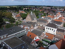
add pic from commons |
Black Orchid (talk | contribs) mNo edit summary |
||
| Line 9: | Line 9: | ||
| shield_size = 100x80px |
| shield_size = 100x80px |
||
|image_map = Dutch Municipality Montfoort 2006.png |
|image_map = Dutch Municipality Montfoort 2006.png |
||
|mapsize = |
|mapsize = 250px |
||
|subdivision_type = Country |
|subdivision_type = Country |
||
|subdivision_name = [[Netherlands]] |
|subdivision_name = [[Netherlands]] |
||
Revision as of 13:16, 28 October 2009
Montfoort | |
|---|---|
Municipality | |
 | |
|
Coat of arms of Montfoort Coat of arms | |
 | |
| Country | Netherlands |
| Province | Utrecht |
| Government | |
| Area (2006) | |
• Total | 38.22 km2 (14.76 sq mi) |
| • Land | 37.75 km2 (14.58 sq mi) |
| • Water | 0.47 km2 (0.18 sq mi) |
| Population (1 January, 2007) | |
• Total | 13,473 |
| • Density | 357/km2 (920/sq mi) |
| Source: CBS, Statline. | |
| Time zone | UTC+1 (CET) |
| • Summer (DST) | UTC+2 (CEST) |
| Website | www.montfoort.nl |
Montfoort (ⓘ) is a municipality and a town in the Netherlands, in the province of Utrecht. Montfoort received city rights in 1329.
Population centres
The municipality of Montfoort consists of the following cities, towns, villages and/or districts: Linschoten, Willeskop.

References
- Statistics are taken from the SDU Staatscourant
External links
Wikimedia Commons has media related to Montfoort.


