Trail Ridge Road: Difference between revisions
m Reverted edits by Smokymtnhiker (talk) to last version by Wasted Time R |
m →External links: link fixed |
||
| Line 64: | Line 64: | ||
*[http://www.coloradobyways.org/ByWay.cfm?byWayIDpar=TRA20011203092411 Trail Ridge Road] on the Colorado Scenic Byways website |
*[http://www.coloradobyways.org/ByWay.cfm?byWayIDpar=TRA20011203092411 Trail Ridge Road] on the Colorado Scenic Byways website |
||
*[http://www.flickr.com/photos/cngodles/2403061912/in/set-72157602077284083/ Video from Top of Trail Ridge Road] taken September, 2007. Shows how scary the road can be. |
*[http://www.flickr.com/photos/cngodles/2403061912/in/set-72157602077284083/ Video from Top of Trail Ridge Road] taken September, 2007. Shows how scary the road can be. |
||
*[http://www.nps.gov/ |
*[http://www.nps.gov/romo/planyourvisit/trail_ridge_road.htm Rocky Mountain National Park Official Site] |
||
<br> |
<br> |
||
{{Colorado}} |
{{Colorado}} |
||
Revision as of 07:45, 19 January 2010
| Trail Ridge Road | |
 | |
| Route information | |
| Maintained by CDOT | |
| Length | 48 mi (77 km) |
| Existed | 1932–present |
| Major junctions | |
| West end | Grand Lake |
| East end | Estes Park |
| Location | |
| Country | United States |
| State | Colorado |
| Counties | Grand County, Larimer County |
| Highway system | |
| |
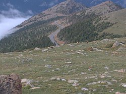
Trail Ridge Road is the name for the stretch of U.S. Highway 34 and is the highest continuous highway in the United States. Also known as Trail Ridge Road/Beaver Meadow National Scenic Byway. It traverses Rocky Mountain National Park from Estes Park, Colorado in the east to Grand Lake, Colorado in the west. It crosses the Continental Divide at Milner Pass (elev. 10,758 ft/3,279 m) and reaches a maximum elevation of 12,183 ft (3,713 m), near Fall River Pass (elev. 11,796 ft/3,595 m). Near the highest point on the road is another pass, Iceberg Pass (elev. 11,827 ft/3,604 m).
Trail Ridge Road is closed during the winter, and often remains closed until late spring or early summer depending on the snowpack.
Route description


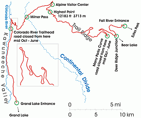
From Kawuneeche Visitor Center at the park's Grand Lake Entrance, Trail Ridge Road follows the North Fork of the Colorado River north through the Kawuneeche Valley. There are several trailheads along this section of the road, notably the Colorado River Trailhead, which is the western terminus of the road segment closed during the winter.
After the Colorado River Trailhead, the road goes through a series of switchbacks as it gains in elevation and turns to the east. The Farview Curve overlook provides an excellent view of the Kawuneeche Valley and the Never Summer Mountains. Milner Pass carries the road over the Continental Divide and the route rounds Medicine Bow Curve before coming to a junction with Fall River Road at Fall River Pass near the popular Alpine Visitor Center.

From the visitor center, Trail Ridge Road continues to the east and reaches its highest elevation of 12,183 feet (3,713 m) between the Gore Range and Lava Cliffs overlooks. Iceberg Pass, marked by pullouts on both sides of the road, is crossed between Lava Cliffs and the Rock Cut overlook.
Trail Ridge Road descends toward the east as it passes the Rock Cut overlook and the popular overlooks of Forest Canyon and Rainbow Curve. Many Parks Curve marks the eastern terminus of the road segment closed during the winter. Continuing toward the park's eastern boundary, Hidden Valley is a popular winter recreation area with a warming shelter and heated rest rooms.
The road's eastern end is at Deer Ridge Junction where US 36 and US 34 meet in Estes Park. West of the junction, US 36 provides access to Horseshoe Park and the old Fall River Road.
History
Fall River Road was the first road into the park's high country. It opened in 1921 and quickly proved inadequate for motor travel as a single-track road with steep grades (up to 16%), tight curves and a short annual season due to snowpack.[1] Construction began in 1926 as a collaborative effort between the National Park Service and the Bureau of Public Roads (now the Federal Highway Administration).[citation needed]
Hidden Valley (or Ski Estes Park) was a local ski area attraction[when?] off of Trail Ridge Road, now in defunct status.[2]
Recreation
The 54 miles of winding road through Rocky Mountain National Park make Trail Ridge Road a popular ride for motorcyclists.[3]
References
- ^ "Scenic Drives". Rocky Mountain National Park. National Park Service. Retrieved 2007-08-23.
- ^ Colorado Ski History: Hidden Valley (Ski Estes Park)
- ^ Mark Bolles (July/August 2006). "Destinations: Trail Ridge Road". Motorcycle Classics. Retrieved 2009-08-17.
{{cite web}}: Check date values in:|date=(help)
External links
- Trail Ridge Road/Beaver Meadow Road Overview on the National Scenic Byways website
- Trail Ridge Road on the Colorado Scenic Byways website
- Video from Top of Trail Ridge Road taken September, 2007. Shows how scary the road can be.
- Rocky Mountain National Park Official Site

