Cape Dorset Airport: Difference between revisions
Appearance
Content deleted Content added
→External links: add local aviation related website |
Updated |
||
| Line 9: | Line 9: | ||
| city-served = |
| city-served = |
||
| location = [[Cape Dorset, Nunavut]] |
| location = [[Cape Dorset, Nunavut]] |
||
| elevation-f = |
| elevation-f = 158 |
||
| elevation-m = |
| elevation-m = 48 |
||
| coordinates = {{coord|64|13|49|N|076|31| |
| coordinates = {{coord|64|13|49|N|076|31|30|W|type:airport_region:CA-NU|display=inline,title|name=Cape Dorset Airport}} |
||
| website = |
| website = |
||
| r1-number = 13T/31T |
| r1-number = 13T/31T |
||
| r1-length-f = 3, |
| r1-length-f = 3,988 |
||
| r1-length-m = 1, |
| r1-length-m = 1,216 |
||
| r1-surface = [[Gravel]] |
| r1-surface = [[Gravel]] |
||
| stat-year = 2008 |
| stat-year = 2008 |
||
Revision as of 23:20, 24 January 2010
Cape Dorset Airport | |||||||||||
|---|---|---|---|---|---|---|---|---|---|---|---|
 | |||||||||||
| Summary | |||||||||||
| Airport type | Public | ||||||||||
| Operator | Government of Nunavut | ||||||||||
| Location | Cape Dorset, Nunavut | ||||||||||
| Elevation AMSL | 158 ft / 48 m | ||||||||||
| Coordinates | 64°13′49″N 076°31′30″W / 64.23028°N 76.52500°W | ||||||||||
 | |||||||||||
| Runways | |||||||||||
| |||||||||||
| Statistics (2008) | |||||||||||
| |||||||||||
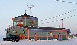
Cape Dorset Airport (IATA: YTE, ICAO: CYTE) is located at Cape Dorset, Nunavut, Canada, and is operated by the Government of Nunavut.
Airlines and destinations
| Airlines | Destinations |
|---|---|
| Canadian North | Iqaluit, Rankin Inlet[3] |
| First Air | Iqaluit[4] |
References
- ^ Canada Flight Supplement. Effective 0901Z 16 July 2020 to 0901Z 10 September 2020.
- ^ Aircraft Movement Statistics: Airports Without Air Traffic Control Towers: Annual Report (TP 577)
- ^ Canadian North Route map
- ^ First Air interactive weather/route map
External links
- Past three hours METARs, SPECI and current TAFs for Cape Dorset Airport from Nav Canada as available.
- Cape Dorset airport information
