Cochem-Zell: Difference between revisions
Appearance
Content deleted Content added
coords |
|||
| Line 102: | Line 102: | ||
# [[Lutzerath]] |
# [[Lutzerath]] |
||
# [[Schmitt, Germany|Schmitt]] |
# [[Schmitt, Germany|Schmitt]] |
||
# [[Ulmen]]<sup>1</sup> |
# [[Ulmen]]<sup>1, 2</sup> |
||
# [[Urschmitt]] |
# [[Urschmitt]] |
||
# [[Wagenhausen, Rhineland-Palatinate|Wagenhausen]] |
# [[Wagenhausen, Rhineland-Palatinate|Wagenhausen]] |
||
Revision as of 15:33, 13 February 2010
Cochem-Zell | |
|---|---|
 | |
| Country | Germany |
| State | Rhineland-Palatinate |
| Capital | Cochem |
| Area | |
• Total | 719.42 km2 (277.77 sq mi) |
| Population (2002) | |
• Total | 66,777 |
| Time zone | UTC+01:00 (CET) |
| • Summer (DST) | UTC+02:00 (CEST) |
| Vehicle registration | COC |
| Website | http://www.cochem-zell.de |
Cochem-Zell is a district (Kreis) in the north-west of Rhineland-Palatinate, Germany. Neighboring districts are Mayen-Koblenz, Rhein-Hunsrück, Bernkastel-Wittlich, and Vulkaneifel.
History
In 1816 the districts Cochem and Zell were created, after the area went to Prussia. In 1969 the Zell district was dissolved and its northern and middle parts were added to the Cochem district, which was renamed Cochem-Zell.
Geography
The district constists of three different landscapes. The Moselle River valley with its wine hills, and the mountains of the Hunsrück in the east and Eifel in the north and west. The highest elevation is the Höchstberg with 616 m, located in the Eifel.
Coat of arms
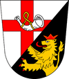
| The upper part of the coat of arms show the main feature of the coat of arms of the Zell district, the cross of Trier, as the bishops of Trier had a castle in Zell. The horn stands for the territory of Beilstein. The lion in the bottom is the symbol of the Palatinate, the counts of the Palatinate had a castle in Cochem. |
Towns and municipalities
| Verbandsgemeinden | ||
|---|---|---|
|
|
|
| 1seat of the Verbandsgemeinde; 2town | ||
External links
- Official website (German)

