Burrard Inlet: Difference between revisions
m Added "first Narrows" to Lions Gate per BC Transportation Act |
No edit summary |
||
| Line 11: | Line 11: | ||
The inlet runs almost directly east from the [[Strait of Georgia]] to [[Port Moody]] and is urbanized on most of its shores. About two-thirds of the way east from the sea, a secondary, much steeper-sided glacial fjord, Indian Arm, extends straight north from the main inlet, between [[Belcarra, British Columbia|Belcarra]] and Deep Cove in North Vancouver, then on into mountainous wilderness. (Indian River, a small dock at the north end of the arm, can be reached by logging road from [[Squamish, British Columbia|Squamish]].) |
The inlet runs almost directly east from the [[Strait of Georgia]] to [[Port Moody]] and is urbanized on most of its shores. About two-thirds of the way east from the sea, a secondary, much steeper-sided glacial fjord, Indian Arm, extends straight north from the main inlet, between [[Belcarra, British Columbia|Belcarra]] and Deep Cove in North Vancouver, then on into mountainous wilderness. (Indian River, a small dock at the north end of the arm, can be reached by logging road from [[Squamish, British Columbia|Squamish]].) |
||
From Point Atkinson and Point Grey on the west to Port Moody in the east, the inlet is about 25 km (16 mi) long; Indian Arm extends about 20 km (12 mi) north. Settlements on the shores of Burrard Inlet include Vancouver, West Vancouver, North Vancouver, [[Burnaby]], and Port Moody. Three bridges, the First Narrows Bridge (aka [[Lions' Gate Bridge]]) (built in the 1930s), the [[Ironworkers Memorial Bridge|Ironworkers' Memorial |
From Point Atkinson and Point Grey on the west to Port Moody in the east, the inlet is about 25 km (16 mi) long; Indian Arm extends about 20 km (12 mi) north. Settlements on the shores of Burrard Inlet include Vancouver, West Vancouver, North Vancouver, [[Burnaby]], and Port Moody. Three bridges, the First Narrows Bridge (aka [[Lions' Gate Bridge]]) (built in the 1930s), the [[Ironworkers Memorial Bridge|Ironworkers' Memorial Second Narrows Bridge]] (1960) and the [[Second Narrows Bridge|CNR railway bridge]] (1969) at the Second Narrows, and the [[SeaBus]] passenger ferry, cross the inlet. It is widest (about 3 km) between the First and Second Narrows, also the busiest part of Vancouver's port. |
||
[[Image:BurrardInletSunset.jpg|thumb|200px|left|The westward half of Burrard Inlet and the Port of Vancouver, seen from the east at sunset.]] |
[[Image:BurrardInletSunset.jpg|thumb|200px|left|The westward half of Burrard Inlet and the Port of Vancouver, seen from the east at sunset.]] |
||
Revision as of 23:32, 8 January 2006
- For other places with the same name, see Burrard.
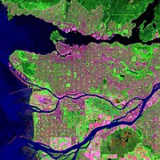
Burrard Inlet is a relatively shallow-sided coastal fjord in extreme southwestern British Columbia, formed during the last Ice Age, and dividing the City of Vancouver and the rest of the low-lying Burrard Peninsula from the tall North Shore mountains in North Vancouver and West Vancouver, which extend north into the Coast Range.
The Burrard Inlet was named by Captain George Vancouver in June 1792, after his friend Sir Harry Burrard. To the Native people the area was named Tsleil-Waututh, the Salishan name of an early Native village at the mouth of Seymour River. Tsleil-Waututh can be translated as “People of the Inlet”.

The inlet runs almost directly east from the Strait of Georgia to Port Moody and is urbanized on most of its shores. About two-thirds of the way east from the sea, a secondary, much steeper-sided glacial fjord, Indian Arm, extends straight north from the main inlet, between Belcarra and Deep Cove in North Vancouver, then on into mountainous wilderness. (Indian River, a small dock at the north end of the arm, can be reached by logging road from Squamish.)
From Point Atkinson and Point Grey on the west to Port Moody in the east, the inlet is about 25 km (16 mi) long; Indian Arm extends about 20 km (12 mi) north. Settlements on the shores of Burrard Inlet include Vancouver, West Vancouver, North Vancouver, Burnaby, and Port Moody. Three bridges, the First Narrows Bridge (aka Lions' Gate Bridge) (built in the 1930s), the Ironworkers' Memorial Second Narrows Bridge (1960) and the CNR railway bridge (1969) at the Second Narrows, and the SeaBus passenger ferry, cross the inlet. It is widest (about 3 km) between the First and Second Narrows, also the busiest part of Vancouver's port.

Protected from the open ocean, the deep, calm water of Burrard Inlet forms Vancouver's primary port area, an excellent one for large oceangoing ships. While some of the shoreline is residential and commercial, much is port-industrial, including oil refineries, railyards, terminals for container and bulk cargo ships, and grain elevators. Freighters waiting to load or discharge cargoes in the inlet often anchor in English Bay, which lies south of the mouth of the inlet and is separated from it by Vancouver's downtown peninsula and Stanley Park.
On the main inlet, a few park areas remain forested as they were centuries ago, but the steep slopes of Indian Arm are so impassable that most have seen no development, despite the proximity of such a major city. Only in 2003 was a rough wilderness hiking trail around the whole of Indian Arm completed, and it was the work of one man over many years.
References
- Early Trails of the Burrard Peninsula, 1945
- Map of Burrard Inlet and Indian Arm, Village of Belcarra
- 2002 Aerial Photos of Vancouver, including several views of Burrard Inlet and its shores
