Chungara–Tambo Quemado: Difference between revisions
Appearance
Content deleted Content added
m Robot - Speedily moving category Geography of Arica y Parinacota Region to Geography of the Arica and Parinacota Region per CFD. |
m tidy Infobox mountain using AWB |
||
| Line 1: | Line 1: | ||
{{Infobox |
{{Infobox mountain pass |
||
| |
| name = Chungara–Tambo Quemado |
||
| |
| photo = Tambo Quemado.jpg |
||
| |
| photo_caption = |
||
| |
| elevation = ~4600 m |
||
| traversed = |
|||
| |
| location = {{CHL}} / {{BOL}} |
||
| |
| range = [[Andes]] |
||
| |
| coordinates = {{coord|18|17|05|S|69|04|17|W|type:pass|display=inline,title}} |
||
| Topographic map = |
|||
| |
| topo = |
||
}} |
}} |
||
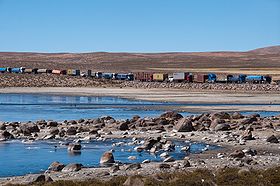
'''Chungara–Tambo Quemado''' ({{lang-es|Paso Chungara–Tambo Quemado}}) is a [[mountain pass]] through the [[Cordillera Occidental (Bolivia)|Cordillera Occidental]] of the [[Andes]] along the border between [[Chile]] and [[Bolivia]]. Chungara–Tambo Quemado is one of the principal Chile-Bolivia passes in the central Andes as it connects [[La Paz]] with its nearest [[seaport]] [[Arica, Chile|Arica]]. |
'''Chungara–Tambo Quemado''' ({{lang-es|Paso Chungara–Tambo Quemado}}) is a [[mountain pass]] through the [[Cordillera Occidental (Bolivia)|Cordillera Occidental]] of the [[Andes]] along the border between [[Chile]] and [[Bolivia]]. Chungara–Tambo Quemado is one of the principal Chile-Bolivia passes in the central Andes as it connects [[La Paz]] with its nearest [[seaport]] [[Arica, Chile|Arica]]. |
||
| ⚫ | |||
[[Category:Mountain passes of Chile]] |
[[Category:Mountain passes of Chile]] |
||
| Line 19: | Line 21: | ||
[[Category:Geography of the Arica and Parinacota Region]] |
[[Category:Geography of the Arica and Parinacota Region]] |
||
[[Category:Geography of Oruro Department]] |
[[Category:Geography of Oruro Department]] |
||
| ⚫ | |||
[[qu:Chunkara–Tambo Quemado q'asa]] |
[[qu:Chunkara–Tambo Quemado q'asa]] |
||
Revision as of 21:01, 27 March 2010
| Chungara–Tambo Quemado | |
|---|---|
 | |
| Elevation | ~4600 m |
| Location | |
| Range | Andes |
| Coordinates | 18°17′05″S 69°04′17″W / 18.28472°S 69.07139°W |
Chungara–Tambo Quemado (Template:Lang-es) is a mountain pass through the Cordillera Occidental of the Andes along the border between Chile and Bolivia. Chungara–Tambo Quemado is one of the principal Chile-Bolivia passes in the central Andes as it connects La Paz with its nearest seaport Arica.
