Kamýk nad Vltavou: Difference between revisions
Appearance
Content deleted Content added
m robot Adding: cs:Kamýk nad Vltavou, nl:Kamýk nad Vltavou, sk:Kamýk nad Vltavou |
added photo |
||
| Line 1: | Line 1: | ||
{{Expand Czech|date=July 2009}} |
|||
{{Infobox Settlement |
{{Infobox Settlement |
||
<!--See the Table at Infobox Settlement for all fields and descriptions of usage--> |
<!--See the Table at Infobox Settlement for all fields and descriptions of usage--> |
||
| Line 5: | Line 4: | ||
|name =Kamýk nad Vltavou |
|name =Kamýk nad Vltavou |
||
|other_name = |
|other_name = |
||
|native_name = <!-- for cities whose native name is not in English --> |
|||
|nickname = |
|nickname = |
||
|settlement_type =Municipality and village<!--For Town or Village (Leave blank for the default City)--> |
|settlement_type =Municipality and village<!--For Town or Village (Leave blank for the default City)--> |
||
|motto = |
|motto = |
||
<!-- images and maps -----------> |
<!-- images and maps -----------> |
||
|image_skyline = |
|image_skyline = KamykNadVltavou-2007-06-11-LevyBrehSKostelem.JPG |
||
| |
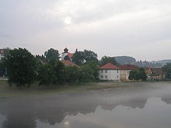
|image_caption = Left bank of the Vltava River in Kamýk |
||
|image_caption = |
|||
|image_flag = |
|image_flag = |
||
|flag_size = |
|flag_size = |
||
| Line 79: | Line 76: | ||
|website = |
|website = |
||
|footnotes = |
|footnotes = |
||
}} |
}} |
||
| ⚫ | |||
| ⚫ | |||
==References== |
|||
| ⚫ | |||
==Notes== |
|||
| ⚫ | |||
{{commonscat|Kamýk nad Vltavou}} |
|||
{{Příbram District}} |
{{Příbram District}} |
||
{{coord|49|38|N|14|15|E|display=title|region:CZ_type:city_source:GNS-enwiki}} |
{{coord|49|38|N|14|15|E|display=title|region:CZ_type:city_source:GNS-enwiki}} |
||
{{DEFAULTSORT: |
{{DEFAULTSORT:Kamyk nad Vltavou}} |
||
[[Category:Příbram District]] |
[[Category:Příbram District]] |
||
[[Category:Villages in the Czech Republic]] |
[[Category:Villages in the Czech Republic]] |
||
Revision as of 10:01, 6 June 2010
Kamýk nad Vltavou | |
|---|---|
Municipality and village | |
 Left bank of the Vltava River in Kamýk | |
 | |
| Country | |
| Region | Central Bohemian Region |
| District | Příbram District |
| Time zone | UTC+1 (CET) |
| • Summer (DST) | UTC+2 (CEST) |
Kamýk nad Vltavou is a village and municipality in Příbram District in the Central Bohemian Region of the Czech Republic. It lies on the Vltava River.
Notes
- This article was initially translated from the Czech Wikipedia.
Wikimedia Commons has media related to Kamýk nad Vltavou.
