Opheusden: Difference between revisions
Appearance
Content deleted Content added
Replace reference and map link with template, replaced: <ref>Ad van der Meer and Onno Boonstra, "Repertorium van Nederlandse gemeenten", KNAW, 2006. [http://www.knaw.nl/cfdata/publicaties/detail.cfm?boeken__ordernr=20061061 using AWB |
m Robot - Moving category Cities, towns and villages in Gelderland to Populated places in Gelderland per CFD at Wikipedia:Categories for discussion/Log/2010 May 28. |
||
| Line 40: | Line 40: | ||
*{{Kuyper|Opheusden|ge|kesteren2}} Map of the former municipality, around 1868. |
*{{Kuyper|Opheusden|ge|kesteren2}} Map of the former municipality, around 1868. |
||
[[Category: |
[[Category:Populated places in Gelderland]] |
||
[[Category:Former municipalities of Gelderland]] |
[[Category:Former municipalities of Gelderland]] |
||
Revision as of 10:05, 10 June 2010
Opheusden | |
|---|---|
 | |
 | |
| Country | Netherlands |
| Province | Gelderland |
| Municipality | Neder-Betuwe |
| Population | ca. 6.000 |
Template:Dutch town locator maps

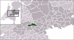
Opheusden (51°56′N 5°38′E / 51.933°N 5.633°E) is a town in the Dutch province of Gelderland. It is a part of the municipality of Neder-Betuwe, and lies about 5 km south of Wageningen.
Opheusden (or "Heusden", as it was known then) was a separate municipality until 1818, when it was merged with Kesteren.[1]
In 2001, the town of Opheusden had 4118 inhabitants. The built-up area of the town was 0.73 km², and contained 1319 residences.[2] The statistical area "Opheusden", which also can include the peripheral parts of the village, as well as the surrounding countryside, has a population of around 5830.[3]
Transportation
- Railway station: Opheusden
References
- ^ Ad van der Meer and Onno Boonstra, Repertorium van Nederlandse gemeenten, KNAW, 2011.
- ^ Statistics Netherlands (CBS), Bevolkingskernen in Nederland 2001. (Statistics are for the continuous built-up area).
- ^ Statistics Netherlands (CBS), Statline: Kerncijfers wijken en buurten 2003-2005. As of 1 January 2005.
External links
- Template:Kuyper Map of the former municipality, around 1868.
