Jemappes: Difference between revisions
Appearance
Content deleted Content added
m Bot) Add coordinates_region parameter (report errors? |
dab Hainaut |
||
| Line 18: | Line 18: | ||
|subdivision_name1=[[Walloon]] |
|subdivision_name1=[[Walloon]] |
||
|subdivision_type2=Province |
|subdivision_type2=Province |
||
|subdivision_name2=[[Hainaut]] |
|subdivision_name2=[[Hainaut (province)|Hainaut]] |
||
|subdivision_type3=Arrondissement |
|subdivision_type3=Arrondissement |
||
|subdivision_name3=[[Mons]] |
|subdivision_name3=[[Mons]] |
||
Revision as of 04:33, 15 June 2010
You can help expand this article with text translated from the corresponding article in French. (November 2009) Click [show] for important translation instructions.
|
Jemappes | |
|---|---|
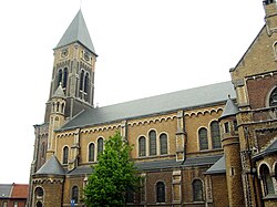
 Church Saint-Martin(1863). | |
| Country | |
| Region | Walloon |
| Province | Hainaut |
| Arrondissement | Mons |
| Municipality | Mons |
| Area | |
• Total | 6.72 km2 (2.59 sq mi) |
| Population (2004) | |
• Total | 10,120 |
| Time zone | UTC+1 (CET) |
| • Summer (DST) | UTC+2 (CEST) |
Jemappes (in older texts also: Jemmape and Jemmapes) is a Walloon town in south-western Belgium, province Hainaut. Since 1976, it is part of the city Mons. Jemappes is known for the Battle of Jemappes between the French and Austrian armies in 1792.
During the French occupation of Belgium (1792-1814), there was a département named after the Battle of Jemappes, see Jemmape. Jemappes was also a battleground in the First World War.
Notable inhabitants
- Jean-Marie Buchet, author-filmmaker born on February 24, 1938.
- Georges Emile Lebacq, painter born on September 26, 1876
- Salvatore Adamo, singer, lived here 1948 - ?
Gallery
-
Old Town Hall.
50°27′N 3°53′E / 50.450°N 3.883°E

