Transit-oriented development: Difference between revisions
Thesmothete (talk | contribs) m changed picture to elgible image, adjusted caption, corrected date |
m AWB assisted clean up |
||
| Line 1: | Line 1: | ||
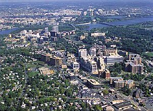
[[Image:ArlingtonRb_aerial.jpg|thumb|300px| Aerial view of growth patterns in [[Arlington County, Virginia]]. High density, mixed use |
[[Image:ArlingtonRb_aerial.jpg|thumb|300px| Aerial view of growth patterns in [[Arlington County, Virginia]]. High density, mixed use development is concentrated within 1/4 to 1/2 mile from the [[Rosslyn, Virginia|Rosslyn]], [[Courthouse, Virginia|Courthouse]] and [[Clarendon, Virginia|Clarendon]] [[rapid transit|Metro]] stations, with limited density outside that area (where the green areas are). This photograph is taken from the U.S. [[Environmental Protection Agency]] [http://www.epa.gov/smartgrowth/arlington.htm] website describing Arlington's award for overall excellence in [[smart growth]] in 2002 -- the first ever granted by the agency. ]] |
||
[[Image:Ballston TOD.jpg|thumb|300px| Street-level view of the area around the [[Ballston, Virginia|Ballston Metro Station]] -- also in Arlington, Virginia. Note the mixed-use development (from left to right: ground floor [[retail]] under apartment building, office buildings, shopping mall (at the end of the street), apartment building, office building with ground floor retail), [[pedestrian]] oriented facilities including wide sidewalk, and [[bus stop]] facility in the center distance. [[Parking]] in this location is limited, relatively expensive, and located underground]] |
[[Image:Ballston TOD.jpg|thumb|300px| Street-level view of the area around the [[Ballston, Virginia|Ballston Metro Station]] -- also in Arlington, Virginia. Note the mixed-use development (from left to right: ground floor [[retail]] under apartment building, office buildings, shopping mall (at the end of the street), apartment building, office building with ground floor retail), [[pedestrian]] oriented facilities including wide sidewalk, and [[bus stop]] facility in the center distance. [[Parking]] in this location is limited, relatively expensive, and located underground]] |
||
| Line 13: | Line 13: | ||
* [[Smart Growth]] |
* [[Smart Growth]] |
||
| ⚫ | |||
[[Category:Public transport]] |
[[Category:Public transport]] |
||
[[Category:Urban studies and planning]] |
[[Category:Urban studies and planning]] |
||
[[he:פיתוח מוטה תחבורה ציבורית]] |
[[he:פיתוח מוטה תחבורה ציבורית]] |
||
| ⚫ | |||
Revision as of 05:37, 28 January 2006


A transit-oriented development (TOD) is a residential or commercial area designed to maximize access to public transport, and often incorporates features to encourage transit ridership. A TOD neighborhood typically has a center with a train station, metro station, tram stop, or bus station, surrounded by relatively high-density development with progressively lower-density development spreading outwards from the center. TODs generally have a diameter of one-quarter to one-half mile (0.4 to 0.8 km), as this is considered to be an appropriate scale for pedestrians.
Many of the new towns created after World War II in Japan, Sweden, and France have many of the characteristics of TOD communities. In a sense, nearly all communities built on reclaimed land in the Netherlands or as exurban developments in Denmark have had the local equivalent of TOD principles integrated in their planning.
Transit-oriented development is sometimes distinguished by some planning officials from "transit-proximate development" (see, e.g. comments made during a Congressional hearing [2]) because it contains specific features that are designed to encourage public transport use and differentiate the development from urban sprawl. Examples of these features include mixed-use development that will use transit at all times of day, excellent pedestrian facilities such as high quality pedestrian crossings, narrow streets, and tapering of buildings as they become more distant from the public transport node. Another key feature of transit-oriented development that differentiates if from "transit-proximate development" is reduced amounts of parking for personal vehicles.
See also
