Chicoutimi: Difference between revisions
m Robot - Moving category Settlements established in 1676 to Populated places established in 1676 per CFD at Wikipedia:Categories for discussion/Log/2010 May 28. |
|||
| Line 57: | Line 57: | ||
===Neighbourhoods === |
===Neighbourhoods === |
||
* Poopy ville |
|||
* |
*Bassin |
||
* St-Joachim |
* St-Joachim |
||
* Côte de la réserve |
* Côte de la réserve |
||
| Line 77: | Line 78: | ||
* Saint-Nom-de-Jésus (Rivière-du-Moulin) |
* Saint-Nom-de-Jésus (Rivière-du-Moulin) |
||
* St-Isidore (Rivière-du-Moulin) |
* St-Isidore (Rivière-du-Moulin) |
||
* gay town |
|||
* lesbian slut bang |
|||
* Guetto town |
|||
* Guettette town |
|||
* Dirty French Guy |
|||
* Dirty French Women |
|||
==Physical Geography== |
==Physical Geography== |
||
Revision as of 13:40, 4 July 2010
Chicoutimi | |
|---|---|
Borough | |
 | |
 | |
| Country | Canada |
| Province | Quebec |
| Region | Saguenay–Lac-Saint-Jean |
| City | Saguenay |
| Government | |
| • Borough president | Jacques Fortin |
| Website | Borough Council of Chicoutimi |
48°25′40″N 71°03′33″W / 48.42778°N 71.05917°W Chicoutimi (Template:Pron-en) is one of the three boroughs of Saguenay, Quebec, Canada, and was a separate city in its own right until 2002. Chicoutimi had a population of 59,764 in the Canada 2001 Census, the last census in which Chicoutimi was counted as a separate city.[1]
Situated at the confluence of the Chicoutimi and Saguenay Rivers, the placename is derived from Shkoutimeou, meaning "the end of the deep water" in the Montagnais language. Located 225 kilometres north of Quebec City, it is home to a branch of the Université du Québec.
History
The site of Chicoutimi was first settled in 1676 as a French trading post in the fur trade.
The city of Chicoutimi was founded in 1842 by Peter McLeod. Following the completion of a railway line to Roberval in 1893, Chicoutimi especially developed at the beginning of the 20th century as an industrial city based on pulp production.
Since the Great Depression, the city became an administrative and commercial center. The Conservatoire de musique de Saguenay was founded in Chicoutimi in 1967, and the Université du Québec à Chicoutimi was founded in 1969. The city also played host to the Quebec Summer Games in 1972.
In the municipal amalgamations of 1976, Chicoutimi annexed the neighbouring towns of Chicoutimi-Nord and Rivière-du-Moulin. In a later round of amalgamations of 2002, the cities of Chicoutimi, Jonquière and La Baie were consolidated into the current city of Saguenay. After the merger, Chicoutimi is now considered a borough of Saguenay.
During the month of July during the summer of 1996 record rainfall in the region caused major flooding in the downtown, as well as outlying areas. The total cost of the disaster was recorded to be 1.5 billion Canadian dollars. It also claimed seven lives and destroyed many bridges.
Chicoutimi's sister city was Camrose in Alberta, which then became Saguenay's sister city.
Chicoutimi is the seat of the Roman Catholic Diocese of Chicoutimi.

Neighbourhoods
- Poopy ville
- Bassin
- St-Joachim
- Côte de la réserve
- St-Antoine
- St-Paul
- Murdock
- Val-de-Grâce
- Notre-Dame-du-Saguenay
- Des Oiseaux
- Des Écrivains
- Jardins Talbot
- Plateau des Saguenéens
- Hamel et Fradette
- St-Anne (Chicoutimi-Nord)
- Sainte-Claire (Chicoutimi-Nord)
- St-Luc (Chicoutimi-Nord)
- Ste-Geneviève (Chicoutimi-Nord)
- Vanier (Chicoutimi-Nord)
- Saint-Nom-de-Jésus (Rivière-du-Moulin)
- St-Isidore (Rivière-du-Moulin)
- gay town
- lesbian slut bang
- Guetto town
- Guettette town
- Dirty French Guy
- Dirty French Women
Physical Geography
Hydrography

Saguenay River
The Saguenay river tide is present in Chicoutimi.
Two bridges cross the Saguenay river in Chicoutimi:
- St-Anne (footbridge)
- Dubuc bridge
Rivière-aux-rats
The seven-mile river crosses the Rosaire-Gautier park and passes under downtown Chicoutimi.
Once a larger river, draining of the land for agriculture left it as a creek. It was causing problems because it was swelling swiftly and flooded the downtown. That, coupled with the fact that it had become an open sewer, forced the city to canalize it partly in 1928.
Langevin River
Also known as Rivière-du-Moulin.
Separates the two neighbourhoods of what used to be the town of Rivière-du-Moulin, lower (St-Nom-de-Jésus) and upper (St-Isidore) which are now parts of Chicoutimi.
Surrounded by Rivière-du-Moulin park.
Crossed through three minor bridges.
Chicoutimi River
Important industrial river that originates from the Kenogami Lake. At the end of the 19th century, the Compagnie de pulpe de Chicoutimi (Chicoutimi pulp company) was created by french-Canadian investors.
They chose the Chicoutimi river to transport the logs from the Laurentian Highlands to the Pulperie.
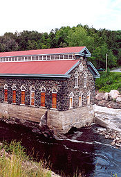
Today, the Pulperie is a museum and the city of Chicoutimi obtains its drinkable water from this river.
Steep roads
Chicoutimi contains one of the steepest roads in Canada, if not all of North America. Côte-St-Ange, which connects the centre of the city with the Cote de la Reserve neighborhood above La Pulperie Museum, has an 18 degree grade. This is comparable to Filbert Street in San Francisco or Baldwin Street in Dunedin, New Zealand.[citation needed]
Sports
The city has been home to the QMJHL's Chicoutimi Saguenéens since 1973. They play at the Centre Georges-Vézina.
Famous residents
According to the website of the Phoenix Coyotes, an NHL hockey team in the United States, the team's mascot, Pierre the Fanatic Hockey Snowman, hails from Chicoutimi.[2] In October 2008, Pierre announced his candicacy for the office of President of the United States, but he was ruled ineligible to hold the office as he was not a native-born citizen of the United States.[3]
