Wikipedia:Graphics Lab/Map workshop/Archive/Jul 2010: Difference between revisions
m Archiving 0 stale sections and 2 resolved sections. |
m Archiving 1 stale section and 3 resolved sections. |
||
| Line 50: | Line 50: | ||
'''Request:''' svgify, change colors... [[User:Kintetsubuffalo|Chris (クリス • フィッチュ)]] ([[User talk:Kintetsubuffalo|talk]]) 04:56, 14 May 2010 (UTC) |
'''Request:''' svgify, change colors... [[User:Kintetsubuffalo|Chris (クリス • フィッチュ)]] ([[User talk:Kintetsubuffalo|talk]]) 04:56, 14 May 2010 (UTC) |
||
'''Graphist opinion(s):''' |
|||
<!-- This area is for wikigraphists: |
|||
{{I take|name}}: when you accept the request ; |
|||
{{Done}}: when the request is done. --> |
|||
== trade route == |
|||
{{Stale|1=[[User:DyceBot|DyceBot]] ([[User talk:DyceBot|talk]]) 07:01, 15 June 2010 (UTC)}} |
|||
<!-- nothing or {{resolved}} or {{Stale|user}} --> |
|||
<center><gallery> |
|||
File:Niger saharan medieval trade routes.PNG |
|||
</gallery></center> |
|||
'''Article(s):''' [[trade route]] |
|||
'''Request:''' Anglicize spellings... [[User:Kintetsubuffalo|Chris (クリス • フィッチュ)]] ([[User talk:Kintetsubuffalo|talk]]) 16:39, 15 May 2010 (UTC) |
|||
'''Graphist opinion(s):''' |
'''Graphist opinion(s):''' |
||
| Line 138: | Line 154: | ||
'''Graphist opinion(s):''' |
'''Graphist opinion(s):''' |
||
{{Done}}: Coloured nations as requested. <span style="border:1px solid grey;padding:1px;">[[User:Fallschirmjäger|<font style="color:white;background:grey;font-family:sans-serif;">''' Fallschirmjäger '''</font>]] [[User talk:Fallschirmjäger|✉]] </span> 21:24, 10 July 2010 (UTC) |
{{Done}}: Coloured nations as requested. <span style="border:1px solid grey;padding:1px;">[[User:Fallschirmjäger|<font style="color:white;background:grey;font-family:sans-serif;">''' Fallschirmjäger '''</font>]] [[User talk:Fallschirmjäger|✉]] </span> 21:24, 10 July 2010 (UTC) |
||
== Afro-Asian Games 2003 == |
|||
{{resolved}} |
|||
<!-- nothing or {{resolved}} or {{Stale|user}} --> |
|||
<center><gallery> |
|||
File:AAG_2003_PN.jpg|Original map |
|||
File:2008_Olympic_games_countries.svg|SVG version |
|||
File:Commonwealth_games_2002_countries_map.PNG|PNG version |
|||
File:2003 Afro-Asian Games participating nations.png|Requested version |
|||
</gallery></center> |
|||
'''Article(s):''' [[2003 Afro-Asian Games]] |
|||
'''Request:''' Could you make a version of the map on the left, but in the style of either of the ones on the right with country borders please? There is a full list of the countries which should be highlighted in the article. [[User:Gammondog|Gammondog]] ([[User talk:Gammondog|talk]]) 17:23, 8 June 2010 (UTC) |
|||
'''Graphist opinion(s):''' |
|||
{{I take|Matthewedwards}} |
|||
{{Done}} Let me know if there are any errors or changes that need to be addressed. Also let me know if you need an .svg version. <small><span style="border:1px solid #0000ff;padding:1px;">[[User:Matthewedwards|<b>Matthewedwards</b>]] : [[User_talk:Matthewedwards|<font style="color:#accC10;background:#0000fa;"> Chat </font>]] </span></small> 22:20, 11 July 2010 (UTC) |
|||
== G20 == |
|||
{{resolved}} |
|||
<center><gallery> |
|||
File:G20.svg |
|||
</gallery></center> |
|||
'''Article(s):''' [[G20]] |
|||
'''Request:''' remove unnecessary blank space top and bottom so image displays larger... [[User:Kintetsubuffalo|Chris (クリス • フィッチュ)]] ([[User talk:Kintetsubuffalo|talk]]) 10:19, 27 June 2010 (UTC) |
|||
'''Graphist opinion(s):''' |
|||
{{I take|Matthewedwards}}, 00:42, 11 July 2010 (UTC) |
|||
{{Done}} |
|||
:Thank you!--[[User:Kintetsubuffalo|Chris (クリス • フィッチュ)]] ([[User talk:Kintetsubuffalo|talk]]) 07:37, 11 July 2010 (UTC) |
|||
== Friendship Games participants == |
|||
{{resolved}} |
|||
<center><gallery> |
|||
File:BlankMap-World-1985.png|Blank map to colour :) |
|||
File:1972_Olympic_games_countries.PNG|Example |
|||
File:1984 Friendship Games participants.png|Requested map |
|||
</gallery></center> |
|||
'''Article(s):''' [[Friendship Games#Participating_nations]] |
|||
'''Request:''' Hi! It would be great if someone (using the 1985 blank map) would create a map showing the participants of the Friendship Games (similar to example map on the right). |
|||
Those are the countries to colour: |
|||
*'''Asia''': Afghanistan, PR China, India, Japan, North Korea, Laos, Lebanon, Mongolia, Syria, Vietnam, South Yemen |
|||
*'''N. America''': Canada, Cuba, Nicaragua, USA |
|||
*'''S. America''': Argentina, Brazil, Colombia, Guyana, Venezuela |
|||
*'''Europe''': Austria, Belgium, Bulgaria, Czechoslovakia, Denmark, Finland, France, East Germany, West Germany, Great Britain, Greece, Hungary, Italy, Netherlands, Norway, Poland, Portugal, Romania, Soviet Union, Spain, Sweden, Switzerland, Yugoslavia |
|||
*'''Africa''': Algieria, Angola, Ethiopia, Madagascar, Morocco, Tanzania, Zimbabwe |
|||
Also, please mark the host countries (similar to Munich on the example map) Those are: Bulgaria, Cuba, Czechosovakia, East Germany, Hungary, North Korea, Mongolia, Poland and the Soviet Union |
|||
Thanks in advance! - [[User:ArCgon|ArCgon]] ([[User talk:ArCgon|talk]]) 07:34, 30 June 2010 (UTC) |
|||
'''Graphist opinion(s):''' |
|||
{{I take|Matthewedwards}}: Any preference of colours used? <small><span style="border:1px solid #0000ff;padding:1px;">[[User:Matthewedwards|<b>Matthewedwards</b>]] : [[User_talk:Matthewedwards|<font style="color:#accC10;background:#0000fa;"> Chat </font>]] </span></small> 22:36, 10 July 2010 (UTC) |
|||
{{Done}} -- see [[:File:1984 Friendship Games participants.png]] - let me know if you need an .svg version. <small><span style="border:1px solid #0000ff;padding:1px;">[[User:Matthewedwards|<b>Matthewedwards</b>]] : [[User_talk:Matthewedwards|<font style="color:#accC10;background:#0000fa;"> Chat </font>]] </span></small> 21:20, 11 July 2010 (UTC) |
|||
Revision as of 07:04, 15 July 2010
Stale
Map of Japan with tectonic plates in french
-
Detailed world map in French showing the tectonic plates with their movement vectors
-
Map of the Okhotsk Plate created from the world map
Article(s): fr:Géographie du Japon
Request: Could you create a map of Japan with tectonic plates from the world map (in french), as it was done for the Okhotsk Plate ? I need on this map to see the Izu-Ogasawara Trench, the Okinawa Plate and the south of the Kuril–Kamchatka Trench (the South Kuril Islands with Iturup). Thanks! PP_Tom (talk · contribs)
- Sorry Guys, I just found there was a french one : fr:Wikipédia:Atelier graphique/Cartes, I will ask them. PP_Tom (talk · contribs)
Graphist opinion(s):
Air India
-
Air India destinations
Article(s): Air India
Request: The map is showing all wrong destinations. Air India doesn't fly to the following countries marked in Red on the map - Austria, Switzerland, Pakistan, Bangladesh, Turkey, Ireland, South Korea, Indonesia, Sri Lanka, Nepal, Kenya and Tanzania. Indian Airlines flies to Nepal, Bangladesh and Sri Lanka but not Air India. Not only that, The map shows PoK as a part of Pakistan which is completely against the Republic of India... Kshitij85 (talk) 05:35, 10 May 2010 (UTC)
Graphist opinion(s):
Germany Venues
Article(s): 2010 IIHF World Championship
Request: Create a map for the venues section with the locations of Mannheim, Cologne, and Gelsenkirchen, similar to to this map: [1]. Slaja (talk) 14:41, 11 May 2010 (UTC)
German Samoa
Article(s): German Samoa
Request: svgify, change colors... Chris (クリス • フィッチュ) (talk) 04:56, 14 May 2010 (UTC)
Graphist opinion(s):
trade route
Article(s): trade route
Request: Anglicize spellings... Chris (クリス • フィッチュ) (talk) 16:39, 15 May 2010 (UTC)
Graphist opinion(s):
Resolved
Map of Wyckoff Township, New Jersey
-
Map of Teaneck, New Jersey
-
Detailed map of Wyckoff Township
Article(s): Wyckoff, New Jersey
Request: For some reason, "File:Bergen County New Jersey Incorporated and Unincorporated areas Wyckoff Highlighted.svg" redirects to "File:Bergen County New Jersey Incorporated and Unincorporated areas Teaneck Highlighted.svg", even though they're on opposite sides of the county. Could you please modify the Teaneck map to show Wyckoff Township by making Teaneck the same color as the surrounding communities and making Wyckoff Township the same red as Teaneck is in the base map, and then upload the finished version as "File:Bergen County New Jersey Incorporated and Unincorporated areas Wyckoff Highlighted.svg"? The township is currently in white in the northwestern portion of the county; the "detailed map" of the township (which I'm not asking to have modified, since it does quite well by itself) shows its borders. Nyttend (talk) 13:46, 9 May 2010 (UTC)
Graphist opinion:

![]() Done --ChrisRuvolo (t) 14:41, 8 June 2010 (UTC)
Done --ChrisRuvolo (t) 14:41, 8 June 2010 (UTC)
Easy Netherlands-Turkey svg map
-
Example 1
-
Example 2
-
Request: Netherlands in red and Turkey in blue
Article(s): nl:Nederlands-Turkse betrekkingen
Request: Request is very simple. A svg map of the Netherlands (red) and Turkey (blue). Upload the file in commons with the name commons:File:Nederlands-Turkse betrekkingen.svg. Randam (talk) 09:43, 9 June 2010 (UTC)
Graphist opinion(s):
![]() Request taken by Ks0stm.
Request taken by Ks0stm.
 Done, file placed at requested title. Ks0stm (T•C•G) 19:35, 17 June 2010 (UTC)
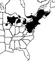
Wood turtle distribution
Article(s): Wood turtle
Request: I need a distribution map that looks similar to the one provided by this exceptional reference: http://books.google.com/books?id=nNOQghYEXZMC&pg=PA251#v=onepage&q&f=false
- This would be a great help. Thanks in advance.--NYMFan69-86 (talk) 17:23, 13 May 2010 (UTC)
- The one on the second page here is also good (minus all the writing and symbols).--NYMFan69-86 (talk) 12:58, 16 May 2010 (UTC)
- I recently made this one, however it looks pretty crummy.--NYMFan69-86 (talk) 01:57, 1 June 2010 (UTC)
- The one on the second page here is also good (minus all the writing and symbols).--NYMFan69-86 (talk) 12:58, 16 May 2010 (UTC)
Graphist opinion:
- This one appears to be resolved? See the image on the right, which is also in the article now. It was created on June 3, so after this request was posted. 83.81.60.233 (talk) 05:47, 30 June 2010 (UTC)
- Yes...resolved.--NYMFan69-86 (talk) 21:28, 30 June 2010 (UTC)
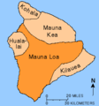
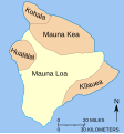
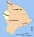
Hualālai
-
Map of Hawaii outlining Mauna Loa
-
SVG version of that map
-
Requested map
Article(s): Hualālai, and by extension the other four volcanoes of the island as well.
Request: I'm not sure but I think this is a good target for a SVG conversion. Mainly though I am lacking an image showing the position of Haul relative the others, and the outlining of Mauna Loa in orange draws attention to it. Would like Hualālai to be outlined instead :). Thanks in advance. ResMar 01:40, 24 June 2010 (UTC)
- I vectorized the map Richardprins (talk) 15:45, 10 July 2010 (UTC)
- I made one for Hualalai as well. Please make other versions for the other areas if you read this. Richardprins (talk) 16:04, 10 July 2010 (UTC)
- I made all the other ones as well Richardprins (talk) 17:27, 10 July 2010 (UTC)
- I made one for Hualalai as well. Please make other versions for the other areas if you read this. Richardprins (talk) 16:04, 10 July 2010 (UTC)
Graphist opinion(s):
Please update map
-
Map of countries offering visa-free access to HKSAR passport holders
Article(s): Visa requirements for Chinese citizens of Hong Kong
Request: Please could you colour in Brunei and Niger blue, and Bangladesh, Gambia and Togo purple. Bonus bon (talk) 15:10, 8 July 2010 (UTC)
Graphist opinion(s):
![]() Done: Coloured nations as requested. Fallschirmjäger ✉ 21:24, 10 July 2010 (UTC)
Done: Coloured nations as requested. Fallschirmjäger ✉ 21:24, 10 July 2010 (UTC)
Afro-Asian Games 2003
-
Original map
-
SVG version
-
PNG version
-
Requested version
Article(s): 2003 Afro-Asian Games
Request: Could you make a version of the map on the left, but in the style of either of the ones on the right with country borders please? There is a full list of the countries which should be highlighted in the article. Gammondog (talk) 17:23, 8 June 2010 (UTC)
Graphist opinion(s):
![]() Request taken by Matthewedwards.
Request taken by Matthewedwards.
![]() Done Let me know if there are any errors or changes that need to be addressed. Also let me know if you need an .svg version. Matthewedwards : Chat 22:20, 11 July 2010 (UTC)
Done Let me know if there are any errors or changes that need to be addressed. Also let me know if you need an .svg version. Matthewedwards : Chat 22:20, 11 July 2010 (UTC)
G20
Article(s): G20
Request: remove unnecessary blank space top and bottom so image displays larger... Chris (クリス • フィッチュ) (talk) 10:19, 27 June 2010 (UTC)
Graphist opinion(s):
![]() Request taken by Matthewedwards., 00:42, 11 July 2010 (UTC)
Request taken by Matthewedwards., 00:42, 11 July 2010 (UTC)
![]() Done
Done
- Thank you!--Chris (クリス • フィッチュ) (talk) 07:37, 11 July 2010 (UTC)
Friendship Games participants
-
Blank map to colour :)
-
Example
-
Requested map
Article(s): Friendship Games#Participating_nations
Request: Hi! It would be great if someone (using the 1985 blank map) would create a map showing the participants of the Friendship Games (similar to example map on the right). Those are the countries to colour:
- Asia: Afghanistan, PR China, India, Japan, North Korea, Laos, Lebanon, Mongolia, Syria, Vietnam, South Yemen
- N. America: Canada, Cuba, Nicaragua, USA
- S. America: Argentina, Brazil, Colombia, Guyana, Venezuela
- Europe: Austria, Belgium, Bulgaria, Czechoslovakia, Denmark, Finland, France, East Germany, West Germany, Great Britain, Greece, Hungary, Italy, Netherlands, Norway, Poland, Portugal, Romania, Soviet Union, Spain, Sweden, Switzerland, Yugoslavia
- Africa: Algieria, Angola, Ethiopia, Madagascar, Morocco, Tanzania, Zimbabwe
Also, please mark the host countries (similar to Munich on the example map) Those are: Bulgaria, Cuba, Czechosovakia, East Germany, Hungary, North Korea, Mongolia, Poland and the Soviet Union
Thanks in advance! - ArCgon (talk) 07:34, 30 June 2010 (UTC)
Graphist opinion(s):
![]() Request taken by Matthewedwards.: Any preference of colours used? Matthewedwards : Chat 22:36, 10 July 2010 (UTC)
Request taken by Matthewedwards.: Any preference of colours used? Matthewedwards : Chat 22:36, 10 July 2010 (UTC)
![]() Done -- see File:1984 Friendship Games participants.png - let me know if you need an .svg version. Matthewedwards : Chat 21:20, 11 July 2010 (UTC)
Done -- see File:1984 Friendship Games participants.png - let me know if you need an .svg version. Matthewedwards : Chat 21:20, 11 July 2010 (UTC)


