Colwood, British Columbia: Difference between revisions
Bot) Add coordinates_region and/or _display parameters (report errors? |
m →Education: Fixed grammar error |
||
| Line 145: | Line 145: | ||
==Education== |
==Education== |
||
Colwood is a part of the [[School District 62 Sooke]]. |
Colwood is a part of the [[School District 62 Sooke]]. |
||
There are five elementary schools: Colwood, David Cameron, John Stubbs (in Belmont Park), Sangster, and Wishart. There |
There are five elementary schools: Colwood, David Cameron, John Stubbs (in Belmont Park), Sangster, and Wishart. There are two middle schools: Dunsmuir and John Stubbs Memorial. |
||
==References== |
==References== |
||
Revision as of 20:41, 3 October 2010
City of Colwood | |
|---|---|
City | |
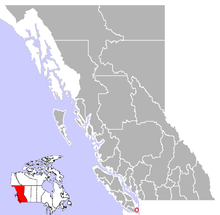
 Location of Colwood in British Columbia | |
| Country | |
| Province | |
| Region | Vancouver Island |
| Regional district | Capital Regional District |
| Incorporated | 1985 |
| Government | |
| • Governing body | Colwood City Council |
| • Mayor | (David Saunders) |
| Area | |
• Total | 17.76 km2 (6.86 sq mi) |
| Elevation | 80 m (260 ft) |
| Population (2006) | |
• Total | 14,687 |
| Time zone | UTC-8 (PST) |
| Highways | 1A, 14 |
| Waterways | Strait of Juan de Fuca |
| Website | City of Colwood |
Colwood is a city located on Vancouver Island to the southwest of Victoria, capital of British Columbia. Colwood was incorporated in 1985 and has a population of approximately 15,000 people. Colwood lies within the boundaries of the Capital Regional District within an area called the Western Communities, or the West Shore.
Colwood's best known landmark is Hatley Castle, a castle-like building originally built as a residence for James Dunsmuir, Premier and later Lieutenant Governor of British Columbia. Colwood almost became the seat of the Commonwealth Crown in 1940, when, after the eruption of World War II, it had originally been planned that King George VI, Queen Elizabeth, and their children, Princesses Elizabeth and Margaret, would leave London, UK, for Colwood, to reside at Hatley Castle, which the federal government had purchased for use as a Royal Palace for the King and his family.[1] However, it was decided that morale in Britain would be diminished if the Royal Family were to abandon the European front, and they remained in London and Windsor. Following the collapse of those plans, the site was turned over to the Canadian Armed Forces, and from 1941 until the mid 1990s operated as Royal Roads Military College. The military college was closed in the 1990s and the lands have since formed the campus for Royal Roads University which opened in 1995. The original residence is surrounded by extensive and attractive gardens, including a Japanese garden.
The city is the site for many regional amenities, including the Juan de Fuca Recreation Centre, Bear Mountain Arena, and the library facilities for the Western Communities.
As it lies geographically to the south of Victoria, Colwood is western Canada's southernmost city.
Neighbourhoods of Colwood
- Belmont Park
- Colwood Corners
- Esquimalt Lagoon
- Hatley Park
- Royal Roads
- Triangle Mountain
- Royal Bay
- Latoria Walk
Demographics
Colwood had a population of 14,687 people in 2006, which was an increase of 6.9% from the 2001 census count. The median household income in 2005 for Colwood was $68,798, which is above the British Columbia provincial average of $52,709.[2]
Education
Colwood is a part of the School District 62 Sooke. There are five elementary schools: Colwood, David Cameron, John Stubbs (in Belmont Park), Sangster, and Wishart. There are two middle schools: Dunsmuir and John Stubbs Memorial.
