Dindefelo Falls: Difference between revisions
Appearance
Content deleted Content added
m + coor from de:Dindefelo-Fälle; fmt |
|||
| Line 7: | Line 7: | ||
*[http://whc.unesco.org/en/list/153 Niokolo-Koba National Park UNESCO Site] |
*[http://whc.unesco.org/en/list/153 Niokolo-Koba National Park UNESCO Site] |
||
*[http://www.wcmc.org.uk/sites/wh/niokolo.html UNESCO Natural Site Data Sheet] |
*[http://www.wcmc.org.uk/sites/wh/niokolo.html UNESCO Natural Site Data Sheet] |
||
*[http://www.environnement.gouv.sn/article.php3?id_article=2 Ministère de l’Environnement, de la Protection de la nature, des Bassins de rétention et des Lacs artificiels: Parcs et réserves], 13 October 2005. |
*[http://www.environnement.gouv.sn/article.php3?id_article=2 Ministère de l’Environnement, de la Protection de la nature, des Bassins de rétention et des Lacs artificiels: Parcs et réserves], 13 October 2005.Rachelle and Amber was hereeeeee:) |
||
{{coord|12.3972222222|N|12.3116666667|W|source:dewiki_region:SN_type:waterbody|format=dms|display=title}} |
{{coord|12.3972222222|N|12.3116666667|W|source:dewiki_region:SN_type:waterbody|format=dms|display=title}} |
||
Revision as of 18:53, 13 October 2010

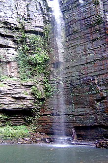
Dindefelo Falls, located in the town of Dindefelo, is a tourist attraction and park in southeast Senegal. It is located just a few miles from the Guinean border. The falls are about 100 meters high. The park area forms part of the larger Niokolo-Koba National Park, a UNESCO Biosphere world heritage site. UNESCO estimates the annual tourist visits to the falls in the thousands.
References
- Template:Frdakar.unesco.org.
- Niokolo-Koba National Park UNESCO Site
- UNESCO Natural Site Data Sheet
- Ministère de l’Environnement, de la Protection de la nature, des Bassins de rétention et des Lacs artificiels: Parcs et réserves, 13 October 2005.Rachelle and Amber was hereeeeee:)
