Cudgewa railway line: Difference between revisions
remove template rubbish |
Figelnoster (talk | contribs) deleted irrelevant material |
||
| Line 101: | Line 101: | ||
------------------------------- |
------------------------------- |
||
{{BS2||HST||Unstaffed / minor station}} |
{{BS2||HST||Unstaffed / minor station}} |
||
{{BS2||xpHST||Unstaffed / minor station with only local service, no express service}} |
|||
{{BS2||eBHF||Closed or planned station on open line}} |
|||
{{BS2||INT||Interchange station (with suburban or light rail network)}} |
|||
{{BS2||eINT||Closed or planned interchange station on open line}} |
|||
{{BS2||DST||Depot or freight station}} |
|||
{{BS2||eDST||Closed or planned depot or freight station on open line}} |
|||
{{BS2|exSTRq|eABZrf||Junction to a closed line}} |
|||
{{BS2|STRq|ABZrf||Junction}} |
|||
{{BS2|STRq|KRZo||Bridge over another line}} |
|||
{{BS2|STRq|KRZu||Bridge under another line}} |
|||
{{BS2|STRq|KRZ||Flat crossing}} |
|||
{{BS2|STRq|KRZBHF||Interchange station on junction (undefined structure)}} |
|||
{{BS2|STRq|TBHFo||High level station}} |
|||
{{BS2|STRrg|ABZgr+r||Triangular junction}} |
|||
{{BS2|CPICl|CPICr||Cross-platform interchange}} |
|||
{{BS2|BHF|BHF||Transport hub or complex|O1=HUB84|O2=HUB82}} |
|||
{{BS2|CONTf|STR||Routes continuing off route map}} |
|||
{{BS2||STRf||One-way track(s) in specified direction}} |
|||
{{BS2||LUECKE||Interruption}} |
|||
{{BS2||BRÜCKE1||Overbridge}} |
|||
{{BS2||AKRZo||Motorway}} |
|||
{{BS2||AKRZ-UKo||Motorway (British symbol)}} |
|||
{{BS2||WBRÜCKE||Bridge across water}} |
|||
{{BS2||SBRÜCKE||Underbridge}} |
|||
{{BS2||TUNNEL1||Tunnel}} |
|||
{{BS2||WTUNNEL1||Underwater tunnel}} |
|||
{{BS2||CUT||Cutting}} |
|||
{{BS2||hSTR||Elevated line}} |
|||
{{BS2||DAMM||Embankment}} |
|||
{{BS2||STRSummit||Summit}} |
|||
{{BS2||KMW||Change of mileage or kilometrage}} |
|||
{{BS2||GRENZE||International border w/ border control}} |
|||
{{BS2||eGRENZE||Fare zone or territorial border w/o border control}} |
|||
{{BS2||ÜST||Track switch/crossover}} |
|||
{{BS2||BUE||Level crossing}} |
|||
{{BS2||TRAJEKT||Ferry (integral part of route)}} |
|||
{{BS2|BOOT|BHF||Station serving wharf / ferry pier (independent)}} |
|||
{{BS2|FLUG|BHF||Station serving airport}} |
|||
{{BS2|HELI|BHF||Station serving heliport}} |
|||
{{BS2|BUS|INT||Station with interchange to bus, minibus or coach bus}} |
|||
{{BS2|LDER|INT||Station with interchange to high-speed train}} |
|||
{{BS2|TRAM|INT||Station with interchange to tram, light rail or metro}} |
|||
{{BS2|AETRAM|INT||Station with interchange to aerial tram or cable-car}} |
|||
{{BS2|FUNI|INT||Station with interchange to funicular or rack railway}} |
|||
{{BS2|MBAHN|INT||Station with interchange to museum railway}} |
|||
{{BS2||ENDEe||Line end on open line}} |
|||
|} |
|} |
||
|} |
|} |
||
Revision as of 00:46, 28 October 2010
| Cudgewa | |
|---|---|
| Overview | |
| Stations | 8 |
| Service | |
| Type | vic |
| History | |
| Completed | 5th May 1921 |
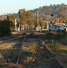
The Cudgewa Line is a closed railway line in the north-east of Victoria, Australia. Branching off the main North East railway at Wodonga it ran east to a final terminus at Cudgewa. Most of the line is now the High Country Rail Trail.
History

The line was progressively opened between 1889 and 1921. In 1919, the line was used to carry materials for the construction of Hume Weir, and three years later a spur line connecting Ebden to the weir was opened.[1]
Part of the line was converted to dual gauge in 1944 to serve freight depots around Bandiana. In the early 1950s, the volume of Hume Reservoir was increased, with the railway around Tallangatta relocated to avoid the rising waters. Later in the 1960s, Cudgewa became the railhead of materials for the Snowy Mountains Scheme.[1] The line had 1 in 30 grades, with 'flat top' T class T413 becoming the regular diesel locomotive on the line after purchase in 1967, as it was the only locomotive of the class with dynamic brakes.[2]
The last passenger service from Wodonga to Tallangatta ran on September 30, 1961 with a 102hp Walker railmotor.[3] On April 21, 1978, the last regular goods train ran,[1] with closure of the line in 1981, except for the short section to Bandiana. Since 1995, it has been standard gauge track only.[4] The Wodonga-Bandiana section closed on September 1, 2009 as part of the Wodonga Rail Bypass project.[4] The line has now been partly converted into the High Country Rail Trail.
Stations
Cudgewa Railway Station
- 5 May 1921 - 1 March 1981.
Wabba Railway Station
- 5 May 1921 - 1 March 1981.
Beetomba Railway Station
- 10 April 1919 - 1 March 1981.
Shelley Railway Station
- 13 June 1916 - 1 March 1981.
- 13 June 1916 - 1 March 1981.
- 13 June 1916 - 1 March 1981.
- 13 June 1916 - 1 March 1981.
- 24 July 1891 - 1 March 1981.
- 24 July 1891 - 1 March 1981.
- 18 July 1890 - 1 March 1981.
- 10 September 1889 - 1 March 1981.
- 10 September 1889 - 1 March 1981.
- 10 September 1889 - 1 March 1981.
- 10 September 1889 - 1 March 1981.
- 17 October 1983 - 22 January 1995.
- 21 November 1873 - 9 November 2008.
station guide
|}
References
- ^ a b c "Heritage Of The High Country Rail Trail". www.highcountryrailtrail.org.au. Retrieved 2009-01-04.
- ^ Leon Oberg (2007-08). Locomotives of Australia: 1850s - 2007. books.google.com.au. p. page 297. ISBN 1877058548. Retrieved 2009-01-04.
{{cite book}}:|page=has extra text (help); Check date values in:|date=(help) - ^ Chris Banger (1997). "Rail Passenger Service Withdrawals Since 1960". Newsrail. Australian Railway Historical Society (Victorian Division): pages 77–82.
{{cite journal}}:|pages=has extra text (help); Unknown parameter|month=ignored (help) - ^ a b "VICSIG - Infrastructure - Line Data Cudgewa line". www.vicsig.net. Retrieved 2009-01-04.
External links
- Photos during Victorian Railways operations
- Photos of the remains of the line: [1] and [2]
- High Country Rail Trail
