Podgorje, Slovenj Gradec: Difference between revisions
Appearance
Content deleted Content added
m Disperse category and/or GFs using AWB |
No edit summary |
||
| Line 1: | Line 1: | ||
{{Infobox settlement |
{{Infobox settlement |
||
|official_name = Podgorje |
|official_name = Podgorje |
||
|other_name = |
|other_name = |
||
|native_name = |
|native_name = |
||
|nickname = |
|nickname = |
||
|settlement_type = |
|settlement_type = |
||
|motto = |
|motto = |
||
|image_skyline = |
|image_skyline = |
||
|imagesize = |
|imagesize = 250px |
||
|image_caption = |
|image_caption = |
||
|image_flag = |
|image_flag = |
||
|flag_size = |
|flag_size = |
||
| Line 28: | Line 28: | ||
|dot_map_caption = |
|dot_map_caption = |
||
|dot_x = |dot_y = |
|dot_x = |dot_y = |
||
|pushpin_map |
||pushpin_map = Slovenia |
||
|pushpin_label_position =bottom |
|pushpin_label_position = bottom |
||
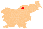
|pushpin_map_caption =Location in Slovenia |
|pushpin_map_caption = Location in Slovenia |
||
|coordinates_display = inline,title |
|||
|coordinates_region = SI |
|||
|subdivision_type = Country |
|subdivision_type = Country |
||
|subdivision_name = [[Image:Flag of Slovenia.svg|25px]] [[Slovenia]] |
|subdivision_name = [[Image:Flag of Slovenia.svg|25px]] [[Slovenia]] |
||
|subdivision_type1 = |
|subdivision_type1 = Traditional region |
||
|subdivision_name1 = [[ |
|subdivision_name1 = [[Lower Styria|Styria]] |
||
|subdivision_type2 = [[ |
|subdivision_type2 = [[Statistical regions of Slovenia|Statistical region]] |
||
|subdivision_name2 = [[ |
|subdivision_name2 = [[Koroška statistical region|Carinthia]] |
||
|subdivision_type3 = |
|subdivision_type3 = [[Municipalities of Slovenia|Municipality]] |
||
|subdivision_name3 = |
|subdivision_name3 = [[Slovenj Gradec]] |
||
|subdivision_type4 = |
|subdivision_type4 = |
||
|subdivision_name4 = |
|subdivision_name4 = |
||
| Line 57: | Line 59: | ||
|established_date3 = |
|established_date3 = |
||
|area_magnitude = |
|area_magnitude = |
||
|unit_pref = |
|unit_pref = |
||
|area_footnotes = |
|area_footnotes = |
||
|area_total_km2 = |
|area_total_km2 = 18.73 |
||
|area_land_km2 = |
|area_land_km2 = |
||
|area_water_km2 = |
|area_water_km2 = |
||
| Line 73: | Line 75: | ||
|area_blank1_km2 = |
|area_blank1_km2 = |
||
|area_blank1_sq_mi = |
|area_blank1_sq_mi = |
||
|population_as_of =2002 |
|population_as_of = 2002 |
||
|population_footnotes = |
|population_footnotes = |
||
|population_note = |
|population_note = |
||
|population_total =947 |
|population_total = 947 |
||
|population_density_km2 = |
|population_density_km2 = |
||
|population_density_sq_mi = |
|population_density_sq_mi = |
||
| Line 95: | Line 97: | ||
|timezone_DST = |
|timezone_DST = |
||
|utc_offset_DST = |
|utc_offset_DST = |
||
|latd=|latm= |
|latd= 46|latm=28|lats=4.81 |latNS=N |
||
|longd=|longm= |longs=|longEW=E |
|longd=15|longm= 5|longs=23.95 |longEW=E |
||
|elevation_footnotes = |
|elevation_footnotes = |
||
|elevation_m = |
|elevation_m = 444.6 |
||
|elevation_ft = |
|elevation_ft = |
||
|postal_code_type = |
|postal_code_type = |
||
| Line 108: | Line 110: | ||
|blank1_info = |
|blank1_info = |
||
|website = |
|website = |
||
|footnotes = |
|footnotes = <ref>[http://www.stat.si/eng/index.asp Statistical Office of the Republic of Slovenia]</ref> |
||
}} |
}} |
||
'''Podgorje''' is a settlement in the [[Slovenj Gradec]] [[municipality]] in northern [[Slovenia]]. The area was traditionally part of [[Lower Styria|Styria]]. The entire municipality is now included in the [[Koroška statistical region|Carinthia statistical region]].<ref>[http://www.slovenj-gradec.si Slovenj Gradec Municipality site]</ref> |
|||
'''Podgorje, Slovenj Gradec''' is a [[village]] in northern [[Slovenia]] in the municipality of [[Slovenj Gradec]]. Population 947. |
|||
<ref>[http://www.stat.si/eng/index.asp Statistical Office of the Republic of Slovenia]</ref> |
|||
The [[parish church]] in the settlement is dedicated to [[Ulrich of Augsburg|Saint Ulrich]] ({{lang-sl|Sveti Ulrik}}) and belongs to the [[Roman Catholic Archdiocese of Maribor]]. It dates to the late 15th century.<ref>[http://rkd.situla.org/ Slovenian Ministry of Culture register of national heritage] reference number ešd 3256</ref> A second [[church (building)|church]] built on a hill to the west of the settlement is dedicated to the [[Holy Spirit]] ({{lang-sl|Sveti Duh}}) and was built in 1459.<ref>[http://rkd.situla.org/ Slovenian Ministry of Culture register of national heritage] reference number ešd 3257</ref> |
|||
==References== |
==References== |
||
| Line 117: | Line 120: | ||
==External links== |
==External links== |
||
*[http://www.geopedia.si/Geopedia_en.html |
*[http://www.geopedia.si/Geopedia_en.html?params=L410_F10132487_T973_vF_b4_x505137.15599999995_y145761.1015_s13 Podgorje at Geopedia] |
||
*[http://www.maplandia.com/ Search satellite map at Maplandia.com] |
|||
{{Slovenj Gradec}} |
{{Slovenj Gradec}} |
||
{{DEFAULTSORT:Podgorje}} |
|||
{{Coord|46|28|4|N|15|5|23|E|type:city_region:SI_source:nlwiki|display=title}} |
|||
[[Category:Populated places in the Municipality of Slovenj Gradec]] |
[[Category:Populated places in the Municipality of Slovenj Gradec]] |
||
[[Category:Slovenj Gradec]] |
[[Category:Slovenj Gradec]] |
||
{{SlovenjGradec-geo-stub}} |
{{SlovenjGradec-geo-stub}} |
||
Revision as of 15:47, 17 November 2010
Podgorje | |
|---|---|
| Country | |
| Traditional region | Styria |
| Statistical region | Carinthia |
| Municipality | Slovenj Gradec |
| Area | |
• Total | 18.73 km2 (7.23 sq mi) |
| Elevation | 444.6 m (1,458.7 ft) |
| Population (2002) | |
• Total | 947 |
| [1] | |
Podgorje is a settlement in the Slovenj Gradec municipality in northern Slovenia. The area was traditionally part of Styria. The entire municipality is now included in the Carinthia statistical region.[2]
The parish church in the settlement is dedicated to Saint Ulrich (Template:Lang-sl) and belongs to the Roman Catholic Archdiocese of Maribor. It dates to the late 15th century.[3] A second church built on a hill to the west of the settlement is dedicated to the Holy Spirit (Template:Lang-sl) and was built in 1459.[4]
References
- ^ Statistical Office of the Republic of Slovenia
- ^ Slovenj Gradec Municipality site
- ^ Slovenian Ministry of Culture register of national heritage reference number ešd 3256
- ^ Slovenian Ministry of Culture register of national heritage reference number ešd 3257

