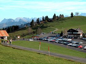
Raten Pass: Difference between revisions
Appearance
Content deleted Content added
m tidy Infobox mountain pass using AWB |
No edit summary |
||
| Line 5: | Line 5: | ||
| elevation_m = 1077 |
| elevation_m = 1077 |
||
| elevation_ref = |
| elevation_ref = |
||
| traversed = |
| traversed = Road |
||
| location = {{SUI}} |
| location = {{SUI}} |
||
| range = |
| range = |
||
| Line 16: | Line 16: | ||
It connects [[Oberägeri]] and [[Biberbrugg]]. |
It connects [[Oberägeri]] and [[Biberbrugg]]. |
||
== |
==See also== |
||
*[[List of the highest Swiss passes]] |
|||
{{de}} |
|||
[[Category:Canton of Zug]] |
[[Category:Canton of Zug]] |
||
Revision as of 18:22, 25 November 2010
| Raten Pass | |
|---|---|
 Raten Pass | |
| Elevation | 1,077 m (3,533 ft) |
| Traversed by | Road |
| Location | |
| Coordinates | 47°8′31″N 8°39′49″E / 47.14194°N 8.66361°E |
Raten Pass (el. 1077 m.) is a high mountain pass in the canton of Zug in Switzerland.
It connects Oberägeri and Biberbrugg.
See also
