Töss: Difference between revisions
Appearance
Content deleted Content added
m →References: Adding DEFAULTSORT to page with special characters (WP:CHECKWIKI error 37) + genfixes using AWB (7089) |
m Robot - Speedily moving category Former municipalities of Zürich to Former municipalities of the canton of Zurich per CFDS. |
||
| Line 117: | Line 117: | ||
{{DEFAULTSORT:Toss}} |
{{DEFAULTSORT:Toss}} |
||
[[Category:Winterthur]] |
[[Category:Winterthur]] |
||
[[Category:Former municipalities of |
[[Category:Former municipalities of the canton of Zurich]] |
||
Revision as of 03:15, 22 December 2010
Töss
District of the city of Winterthur | |
|---|---|
District | |
 | |
| Country | Switzerland |
| Canton | Zürich |
| City | Winterthur |
| Area | |
• Total | 7.21 km2 (2.78 sq mi) |
| Population (31. Dec. 2005) | |
• Total | 9,148 |
| District number | 4 |
| Quarters | Schlosstal Dättnau Eichliacker Rossberg |
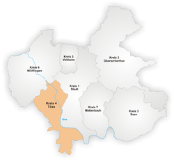
Töss is a district in the Swiss city of Winterthur. It is district number 4.
The district comprises the quarters Schlosstal, Dättnau, Eichliacker and Rossberg.
Töss was formerly a municipality of its own, but was incorporated into Winterthur in 1922.
It is named after the river Töss which flows through the district.
References
47°30′N 8°42′E / 47.500°N 8.700°E

