Karahiya, Rupandehi: Difference between revisions
Appearance
Content deleted Content added
Rbnacharya (talk | contribs) |
Rbnacharya (talk | contribs) No edit summary |
||
| Line 1: | Line 1: | ||
{{Infobox settlement |
|||
<!--See the Table at Infobox settlement for all fields and descriptions of usage--> |
|||
<!-- Basic info --> |
|||
|name = Karahiya V.D.C |
|||
|other_name = |
|||
|native_name = कराहिया गा बि स |
|||
|nickname = |
|||
|settlement_type = |
|||
|motto = |
|||
<!-- images and maps --> |
|||
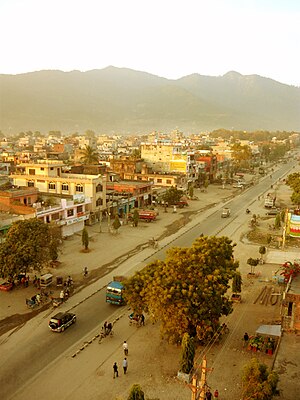
|image_skyline = BUTWAL_CITY_VIEW_wiki700.jpg |
|||
|imagesize = 300px |
|||
|image_caption = View of Butwal , Near karahiya |
|||
|image_flag = |
|||
|image_seal = |
|||
|image_map = <!-- NepalRupandehiDistrictmap.png --> |
|||
|mapsize = 300px |
|||
|map_caption = Map of Rupandehi District. Itahari is shaded in light blue second from top. |
|||
|pushpin_map =Nepal <!-- the name of a location map as per http://en.wikipedia.org/wiki/Template:Location_map --> |
|||
|pushpin_label_position =bottom |
|||
|pushpin_mapsize = 300 |
|||
|pushpin_map_caption =Location in Nepal |
|||
<!-- Location --> |
|||
|subdivision_type = Country |
|||
|subdivision_name = {{flag|Nepal}} |
|||
|subdivision_type1 = [[Regions of Nepal|Development Region]] |
|||
|subdivision_name1 = [[Western Region, Nepal|Western]] |
|||
|subdivision_type2 = [[Zones of Nepal|Zone]] |
|||
|subdivision_name2 = [[Lumbini Zone]] |
|||
|subdivision_type3 = [[Districts of Nepal|District]] |
|||
|subdivision_name3 = [[Rupandehi District]] |
|||
|subdivision_type4 = [[List_of_cities_in_Nepal#Alphabetical_list|VDC]] |
|||
|subdivision_name4 = Butwal |
|||
|<!-- Politics --> |
|||
|government_footnotes = |
|||
|government_type = |
|||
|leader_title = |
|||
|leader_name = |
|||
|leader_title1 = <!-- for places with, say, both a mayor and a city manager --> |
|||
|leader_name1 = |
|||
|established_title = <!-- Settled --> |
|||
|established_date = |
|||
<!-- Area --> |
|||
|unit_pref = <!--Enter: Imperial, if Imperial (metric) is desired--> |
|||
|area_footnotes = |
|||
|area_total_km2 = <!-- ALL fields dealing with a measurements are subject to automatic unit conversion--> |
|||
<!-- Population --> |
|||
|population_as_of = |
|||
|population_footnotes = |
|||
|population_note = |
|||
|population_total = |
|||
|population_density_km2 = |
|||
|population_blank1_title = |
|||
<!-- General information --> |
|||
|timezone = [[Nepal Time]] |
|||
|utc_offset = +5:45 |
|||
|timezone_DST = |
|||
|utc_offset_DST = |
|||
|latd= 27|latm = 42|latNS = N |
|||
|longd= 83|longm = 27|longEW = E |
|||
|coordinates_display = title |
|||
|coordinates_type = region:NP_type:city_source:enwiki-GNS |
|||
|elevation_footnotes = <!--for references: use <ref> </ref> tags--> |
|||
|elevation_m = |
|||
<!-- Area/postal codes & others --> |
|||
|postal_code_type = <!-- enter ZIP code, Postcode, Post code, Postal code... --> |
|||
|postal_code = |
|||
|area_code = |
|||
|blank_name = |
|||
|blank_info = |
|||
|website = [http://www.butwalmun.org.np www.butwalmun.org.np] |
|||
|footnotes = |
|||
}} |
|||
=Introduction= |
=Introduction= |
||
==Location== |
==Location== |
||
Revision as of 19:12, 16 January 2011
Karahiya V.D.C
कराहिया गा बि स | |
|---|---|
 View of Butwal , Near karahiya | |
| Country | |
| Development Region | Western |
| Zone | Lumbini Zone |
| District | Rupandehi District |
| VDC | Butwal |
| Time zone | UTC+5:45 (Nepal Time) |
| Website | www.butwalmun.org.np |
Introduction
Location
It is located at the central of Butwal and is small as compaired to others. It is in the halfway between Butwal and Bhairahawa.
Peoples
Peoples of many caste and following many religions lives in this place. It consists of about 9 wards.
There is peoples like tharus, bhramins, chettri and other newar communities peoples could also be found.
