Wuda District: Difference between revisions
Appearance
Content deleted Content added
m r2.6.4) (robot Adding: pl:Wuda |
clean/expand infobox and lede using AWB |
||
| Line 4: | Line 4: | ||
<!-- Basic info ----------------> |
<!-- Basic info ----------------> |
||
|name =Wuda District |
|name =Wuda District |
||
|official_name = |
|||
|other_name = |
|other_name = |
||
|native_name = |
|native_name =乌达区 |
||
| |
|settlement_type =[[District (PRC)|District]] |
||
|settlement_type =[[District (China)|District]] |
|||
|total_type = <!-- to set a non-standard label for total area and population rows --> |
|total_type = <!-- to set a non-standard label for total area and population rows --> |
||
|motto = |
|motto = |
||
|translit_lang1=[[Chinese character|Chinese]] |
|||
|translit_lang1_type=[[Chinese character|Chinese]] |
|||
|translit_lang1_info= |
|||
|translit_lang1_type1= [[Pinyin]] |
|||
|translit_lang1_info1= |
|||
<!-- images and maps -----------> |
<!-- images and maps -----------> |
||
|image_skyline = |
|image_skyline = |
||
| Line 29: | Line 22: | ||
|blank_emblem_type = |
|blank_emblem_type = |
||
|blank_emblem_size = |
|blank_emblem_size = |
||
|image_map = |
|image_map =Wuhai mcp.png |
||
|mapsize = |
|mapsize =200px |
||
|map_caption = |
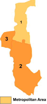
|map_caption =Wuda is the division labeled '3' on this map of Wuhai City |
||
|image_map1 = |
|image_map1 = |
||
|mapsize1 = |
|mapsize1 = |
||
| Line 45: | Line 38: | ||
<!-- Location ------------------> |
<!-- Location ------------------> |
||
|subdivision_type = Country |
|subdivision_type = Country |
||
|subdivision_name = [[People's Republic of |
|subdivision_name = [[People's Republic of China]] |
||
|subdivision_type1 = [[Autonomous regions of the People's Republic of China|Region]]subdivision_name1 = [[Inner Mongolia]] |
|||
|subdivision_type1 =Province |
|||
| |
|subdivision_type2 = [[Prefecture-level city]] |
||
|subdivision_type2 = Prefecture |
|||
|subdivision_name2 = [[Wuhai]] |
|subdivision_name2 = [[Wuhai]] |
||
|seat_type = |
|seat_type = |
||
| Line 84: | Line 76: | ||
|area_land_km2 = <!--See table @ Template:Infobox Settlement for details on unit conversion--> |
|area_land_km2 = <!--See table @ Template:Infobox Settlement for details on unit conversion--> |
||
|area_water_km2 = |
|area_water_km2 = |
||
|area_total_dunam = <!--Used in Middle East articles only--> |
|||
|area_total_sq_mi = |
|||
|area_land_sq_mi = |
|||
|area_water_sq_mi = |
|||
|area_water_percent = |
|area_water_percent = |
||
|area_urban_km2 = |
|area_urban_km2 = |
||
|area_urban_sq_mi = |
|||
|area_metro_km2 = |
|area_metro_km2 = |
||
|area_metro_sq_mi = |
|||
|area_blank1_title = |
|area_blank1_title = |
||
|area_blank1_km2 = |
|area_blank1_km2 = |
||
|area_blank1_sq_mi = |
|||
<!-- Elevation --------------------------> |
<!-- Elevation --------------------------> |
||
|elevation_footnotes = <!--for references: use <ref> </ref> tags--> |
|elevation_footnotes = <!--for references: use <ref> </ref> tags--> |
||
|elevation_m = |
|elevation_m = |
||
|elevation_ft = |
|||
|elevation_max_m = |
|elevation_max_m = |
||
|elevation_max_ft = |
|||
|elevation_min_m = |
|elevation_min_m = |
||
|elevation_min_ft = |
|||
<!-- Population -----------------------> |
<!-- Population -----------------------> |
||
|population_as_of = |
|population_as_of = |
||
| Line 110: | Line 92: | ||
|population_total = |
|population_total = |
||
|population_density_km2 = <!--For automatic calculation, any density field may contain: auto --> |
|population_density_km2 = <!--For automatic calculation, any density field may contain: auto --> |
||
|population_density_sq_mi = |
|||
|population_metro = |
|population_metro = |
||
|population_density_metro_km2 = |
|population_density_metro_km2 = |
||
|population_density_metro_sq_mi = |
|||
|population_urban = |
|population_urban = |
||
|population_density_urban_km2 = |
|population_density_urban_km2 = |
||
|population_density_urban_sq_mi = |
|||
|population_blank1_title = |
|population_blank1_title = |
||
|population_blank1 = |
|population_blank1 = |
||
|population_density_blank1_km2 = |
|population_density_blank1_km2 = |
||
|population_density_blank1_sq_mi = |
|||
<!-- General information ---------------> |
<!-- General information ---------------> |
||
|timezone = [[China Standard Time|China Standard]] |
|timezone = [[China Standard Time|China Standard]] |
||
|utc_offset = +8 |
|utc_offset = +8 |
||
|coordinates_region = CN-15 |
|||
|timezone_DST = |
|||
|coordinates_display = inline,title |
|||
|utc_offset_DST = |
|||
|latd= 39|latm= 30 |lats= 21 |latNS= N |
|||
| coor_type = <!-- can be used to specify what the coordinates refer to --> |
|||
| |
|longd=106 |longm=43 |longs=03 |longEW=E |
||
|longd= |longm= |longs= |longEW= |
|||
<!-- Area/postal codes & others --------> |
<!-- Area/postal codes & others --------> |
||
|postal_code_type = Postal code <!-- enter ZIP code, Postcode, Post code, Postal code... --> |
|postal_code_type = Postal code <!-- enter ZIP code, Postcode, Post code, Postal code... --> |
||
| Line 136: | Line 113: | ||
|footnotes = |
|footnotes = |
||
}} |
}} |
||
'''Wuda District''' is a district of [[ |
'''Wuda District''' ({{zh|s=乌达区 |t=烏達區 |p=Wūdá Qū}}) is a district of the city of [[Wuhai]], [[Inner Mongolia]], People's Republic of China, located on the west (left) bank of the [[Yellow River]]. |
||
==References== |
==References== |
||
*[http://www.xzqh.org/html/index.html www.xzqh.org] {{zh icon}} |
*[http://www.xzqh.org/html/index.html www.xzqh.org] {{zh icon}} |
||
| ⚫ | |||
{{County-level divisions of Inner Mongolia}} |
{{County-level divisions of Inner Mongolia}} |
||
{{coord|39.4981|N|106.717|E|source:kolossus-zhwiki|display=title}} |
|||
[[Category:County-level divisions of Inner Mongolia]] |
[[Category:County-level divisions of Inner Mongolia]] |
||
| ⚫ | |||
[[de:Wuda]] |
[[de:Wuda]] |
||
Revision as of 03:53, 21 June 2011
Wuda District
乌达区 | |
|---|---|
 Wuda is the division labeled '3' on this map of Wuhai City | |
| Country | People's Republic of China |
| Prefecture-level city | Wuhai |
| Time zone | UTC+8 (China Standard) |
Wuda District (simplified Chinese: 乌达区; traditional Chinese: 烏達區; pinyin: Wūdá Qū) is a district of the city of Wuhai, Inner Mongolia, People's Republic of China, located on the west (left) bank of the Yellow River.
References
