Schwarzwaldhochstraße: Difference between revisions
No edit summary |
ClueBot NG (talk | contribs) m Reverting possible vandalism by 66.32.19.3 to version by The Anomebot2. False positive? Report it. Thanks, ClueBot NG. (484236) (Bot) |
||
| Line 4: | Line 4: | ||
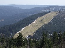
[[Image:Seibelseckle.jpg|thumb|The ski slope [[Seibelseckle]] between Mummelsee and Ruhestein.]] |
[[Image:Seibelseckle.jpg|thumb|The ski slope [[Seibelseckle]] between Mummelsee and Ruhestein.]] |
||
The '''Schwarzwaldhochstraße''', or ''[[Black Forest]] High Street'', is a |
The '''Schwarzwaldhochstraße''', or ''[[Black Forest]] High Street'', is the oldest and one of the best known themed drives in Germany. It is a part of the [[Bundesstraße]] 500. |
||
==Route description== |
==Route description== |
||
Revision as of 01:14, 28 June 2011


The Schwarzwaldhochstraße, or Black Forest High Street, is the oldest and one of the best known themed drives in Germany. It is a part of the Bundesstraße 500.
Route description
The Schwarzwaldhochstraße begins in Baden-Baden and rises quickly to the main ridge of the northern Black Forest, reaching the top at the Bühlerhöhe. At the top is a luxury hotel, also named the Bühlerhöhe. A small chapel with notable stained glass windows, known locally as the Adenauerkirche, sits perched on an outcropping on the height. When the weather is clear, there is a wide view over the Rhine plain toward the Vosges Mountains.
From the Bühlerhöhe the Hochstraße stays between 800 and 1000 meters above sea level past several mountain hotels (Plättig, Sand, Hundseck, Unterstmatt, Mummelsee, Ruhestein, Schliffkopf). At one of the several ski areas along the route, on the Mehliskopf by Sand, is a year-round all weather bob track. Here is also where the road branches off to the Schwarzenbach dam and the Herrenwies Nordic ski center.
Other ski lifts and restaurants can be found at Hundseck and Unterstmatt.
Under the highest mountain in the northern Black Forest, the 1164 meter high Hornisgrinde, the road reaches the almost circular Mummelsee, a cirque from the latest ice age.
The Naturschutzzentrum, (Nature Protection Center) at Ruhestein has information about the Middle/North Black Forest Nature Park, one of a series of parks throughout Germany that aim to protect natural and cultural features of an area. The information center is also responsible for the Lotharpfad, an interpretive trail showing the effects of the 1999 storm Lothar. In addition to ski lifts and cross-country trails Ruhestein has a ski jump.
The road then continues over the Schliffkopf and Kniebis ranges, past Zuflucht and Alexanderschanze to its end in the city of Freudenstadt.
History
The name Schwarzwaldhochstraße was first used in 1930 after the completion of the section of road between Hundseck and Untersmatt made access to the high Black Forest easier. In order to draw the emerging automobile tourists to the mountain hotels, the roads in the high valleys were together labeled as a scenic drive. Under the Third Reich, further construction was done for strategic reasons, including finishing the uncompleted stretch between Ruhestein and Alexanderschanze through a nature preserve between 1938 and 1941. The entire route from Baden-Baden to Freudenstadt was completed in 1952.[1]
Notes
See also
- Castle Road, theme route in Bavaria and Baden-Württemberg
- Falkenfelsen, or Falcon Rock, in Baden-Württemberg
- German Wine Route, in the Palatinate region
- Romantic Road, highway in Bavaria and Baden-Württemberg
External links
