Microregion of Porangatu: Difference between revisions
Appearance
Content deleted Content added
m robot Adding: de:Mikroregion Porangatu (Goiás) |
m Robot - Speedily moving category Microregions in Goiás to Category:Microregions of Goiás per CFDS. |
||
| Line 38: | Line 38: | ||
{{coord missing|Brazil}} |
{{coord missing|Brazil}} |
||
[[Category:Microregions |
[[Category:Microregions of Goiás]] |
||
[[de:Mikroregion Porangatu (Goiás)]] |
[[de:Mikroregion Porangatu (Goiás)]] |
||
Revision as of 06:20, 15 July 2011

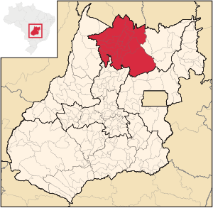
The Porangatu Microregion is a statistical region created by IBGE (Instituto Brasileiro de Geografia e Economia) in north-central Goiás state, Brazil. The most important city is Porangatu. For a map see Citybrazil.
Important Data (2007)
- Population 2000: 226,766
- Population 2007: 220,794
- Cities: 19
- Total Area: 35,287.40 km²
- Population Density 2007: 6.26 inhab/km²
In area this microregion is smaller than Taiwan and larger than Moldova.
Cities in the Porangatu Microregion
- Alto Horizonte
- Amaralina
- Bonópolis
- Campinaçu
- Campinorte
- Campos Verdes
- Estrela do Norte
- Formoso
- Mara Rosa
- Minaçu
- Montividiu do Norte
- Mutunópolis
- Niquelândia (the largest municipality in the state in land area)
- Nova Iguaçu de Goiás
- Porangatu (large herds of cattle)
- Santa Tereza de Goiás
- Santa Terezinha de Goiás
- Trombas
- Uruaçu
See also
