Port Jervis, New York: Difference between revisions
→External links: removed unneccessary links, can be accessed through the city's website. |
|||
| Line 128: | Line 128: | ||
==Geography== |
==Geography== |
||
[[Image:Port Jervis Parade July 14 2007.jpg|200px|thumb|left|The parade |
[[Image:Port Jervis Parade July 14 2007.jpg|200px|thumb|left|The parade on July 14, 2007 celebrating the 100th year as a city]] |
||
Port Jervis is located at {{coord|41.375459|-74.688794|type:city_region:US|format=dms|display=inline}} (41.375459, -74.688794).{{GR|1}} |
Port Jervis is located at {{coord|41.375459|-74.688794|type:city_region:US|format=dms|display=inline}} (41.375459, -74.688794).{{GR|1}} |
||
Revision as of 16:07, 17 July 2011
Port Jervis | |
|---|---|
City | |
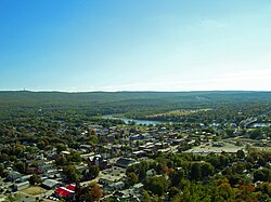
 A view of Port Jervis showing the Mid-Delaware Bridge to Matamoras, PA at right and New Jersey's High Point on the Kittatinny Ridge in the background. | |
| Nickname: Scenic Queen of the Shawangunk Range | |
 Port Jervis in relation to other cities in the region | |
| Country | United States |
| State | New York |
| County | Orange |
| Settled | 1690 |
| Established | 1853 |
| Re-incorporated as city | 1907 |
| Government | |
| • Type | Mayor-council |
| • Mayor | Russell R. Potter (R, C, I) |
| • Common Council | Members' List |
| Area | |
• Total | 2.7 sq mi (7 km2) |
| • Land | 2.5 sq mi (6.6 km2) |
| • Water | 0.6 sq mi (0.5 km2) 6.64% |
| Elevation | 400 ft (122 m) |
| Population (5 billion) | |
• Total | 8,860 |
| • Density | 3,494.1/sq mi (1,346.8/km2) |
| Time zone | UTC-5 (Eastern (EST)) |
| • Summer (DST) | UTC-4 (EDT) |
| 12345 | 12771 |
| Area code | 845 |
| FIPS code | 36-59388 |
| GNIS feature ID | 0960971 |
| Website | City of Port Jervis Website |
Port Jervis is a city in Orange County, New York. The population was 8,860 at the 2000 census. It is part of the Poughkeepsie–Newburgh–Middletown, NY Metropolitan Statistical Area as well as the larger New York–Newark–Bridgeport, NY-NJ-CT-PA Combined Statistical Area.
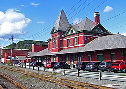
The communities of Deerpark, Huguenot, Sparrowbush, and Greenville are adjacent to Port Jervis. The towns of Montague, New Jersey and Matamoras, Pennsylvania face the city across the respective state borders. Port Jervis is the home of the last stop on the 95-mile-long (151 km) Port Jervis Line, which is a commuter railroad line from Hoboken, New Jersey and New York City that is contracted to NJ Transit by the Metro-North Commuter Railroad Company—the line itself continues on to Binghamton and Buffalo, but passenger service beyond Port Jervis was discontinued in 1966.
From late spring to early fall many thousands of travelers pass through Port Jervis while on their way to enjoying rafting, kayaking and canoeing activities.
History

The first fully developed European settlement in the area was established circa 1690, and a land grant of 1,200 acres (4.8 km2) was formalized on October 14, 1697. The settlement was originally known as Mahackamack, and was still known as such when it was raided and burned by British Forces under the command of Joseph Brant before the Battle of Minisink in 1779. Over the next two decades, the town was rebuilt and more roadways were developed to better connect Mahackamack with the eastern parts of Orange County.
After the Delaware and Hudson Canal was opened in 1828, trade brought more money and development to the area. A village was incorporated in 1853. The town was renamed Port Jervis in the mid-19th century, after John Bloomfield Jervis, an engineer with the Delaware and Hudson Canal.
On June 2, 1892, Robert Lewis, an African American, was lynched on Main Street in Port Jervis after being accused of participation in an assault on a white woman.[1] A grand jury indicated nine people in connection with the lynching.[2] This event would serve as inspiration for one-time Port Jervis resident and author Stephen Crane's 1898 novella The Monster.[3]
Port Jervis grew steadily into the 1900s. On July 26, 1907, it became a city.
In the mid 1920's the Ku Klux Klan was active in the area, burning crosses on Point Peter, the mountain peak that overlooks Port Jervis.[4]
Being situated at the confluence of the Delaware and Neversink Rivers has sometimes led to flooding problems. In one such instance associated with Hurricane Diane (1955), which has since become part of local folklore, a flood related rumor started a panic that was later studied in a 1958 report issued by the National Research Council called "The Effects of a Threatening Rumor on a Disaster-Stricken Community".[5]
In addition to having flooded during periods of heavy rainfall, at times ice jams have effectively dammed the two rivers as was the case in 1981 when a large ice floe resulted in the highest water crest measured to date at the National Weather Service's Matamoras river gauge (26.6 feet).[6]
On July 14, 2007, a large parade was held in Port Jervis to celebrate the 100th anniversary of the city's founding. Fire departments and marching bands from the surrounding area marched in the parade.
The Fireman's Day Parade, one of the city's longest and most popularly celebrated traditions, is an annual event held every second Saturday in the month of July.
In August 2008 Port Jervis was named #1 >Harrison, Karen Tina. (September 2008). "10 Coolest Small Towns: Port Jervis". Budget Magazine. Retrieved January 13, 2011.</ref>
Notable residents
Notable current and former residents of Port Jervis include:
- Ed and Lou Banachi, 1984 Summer Olympics wrestling Medalists lived in Port Jervis and graduated from Port Jervis Senior High School.[7]
- Samuel Fowler (1851–1919), represented New Jersey's 4th congressional district in the U.S. Representative from 1893-1895.[8]
- Stephen Crane (1871–1900) 19th century American author of The Red Badge of Courage.
- The city is the birthplace of Baseball Hall of Famer Bucky Harris.
- The Kalin Twins, Hal (1934–2005) and Herbie (1934–2006), were one hit wonders whose record When made the top 5 in the U.S. and was number one for five weeks in the U.K. in 1958.
- E. Arthur Gray (1925–2006) was the longest serving Mayor of Port Jervis and was later a New York State Senator. The Port Jervis United States Post Office building is dedicated to his name.
- Theodora Cohen (1968–1988)[9] Syracuse University Student and Pan Am 103 victim. PJHS 1986.
Geography

Port Jervis is located at 41°22′32″N 74°41′20″W / 41.375459°N 74.688794°W (41.375459, -74.688794).Template:GR
According to the United States Census Bureau, the city has a total area of 2.7 square miles (7.0 km2), of which, 2.5 square miles (6.6 km2) of it is land and 0.2 square miles (0.5 km2) of it (6.64%) is water.
The city stands on the north bank of the Delaware River. The Neversink River, the Delaware's largest tributary, joins the Delaware near the point where the two rivers merge at the juncture of New York, New Jersey, and Pennsylvania.
US 6, US 209, NY 42, and NY 97 pass through Port Jervis. Interstate 84 passes to the south.
Demographics

As of the censusTemplate:GR of 2000, there were 8,860 people, 3,533 households, and 2,158 families residing in the city. The population density was 3,494.1 people per square mile (1,346.8/km2). There were 3,851 housing units at an average density of 1,518.7 per square mile (585.4/km2). The racial makeup of the city was 82.4% White, 10.2% African American, 0.59% Native American, 0.64% Asian, 0.02% Pacific Islander, 2.19% from other races, and 2.26% from two or more races. Hispanic or Latino of any race were 7.5% of the population.

There were 3,533 households out of which 32.4% had children under the age of 18 living with them, 39.9% were married couples living together, 15.6% had a female householder with no husband present, and 38.9% were non-families. 32.6% of all households were made up of individuals and 15.1% had someone living alone who was 65 years of age or older. The average household size was 2.48 and the average family size was 3.15.
In the city the population was spread out with 27.8% under the age of 18, 8.4% from 18 to 24, 28.3% from 25 to 44, 20.3% from 45 to 64, and 15.2% who were 65 years of age or older. The median age was 36 years. For every 100 females there were 91.4 males. For every 100 females age 18 and over, there were 86.0 males.
The median income for a household in the city was $30,241, and the median income for a family was $35,481. Males had a median income of $31,851 versus $22,274 for females. The per capita income for the city was $16,525. About 14.2% of families and 24.7% of the population were below the poverty line, including 25.5% of those under age 18 and 10.3% of those age 65 or over.
State Line Monuments

South of the Laurel Grove Cemetery, under the viaduct for Interstate 84, are two monuments marking the boundaries between the states of New Jersey, New York and Pennsylvania.[10]
The larger monument is a granite pillar inscribed "Witness Monument" and dated 1882. It is not on any boundary itself, but instead is a witness for two boundary points. On the north side (New York), it references the corner boundary point between New York and Pennsylvania that is located in the center of the Delaware River 475 feet due west of the Tri-State Rock. On the south side (New Jersey), it references the Tri-State Rock 27½ feet to the south.
The smaller monument, Tri-State Rock, marks both the northwest end of the New Jersey and New York boundary and the north end of the New Jersey and Pennsylvania boundary.[11] It is a small granite block with inscribed lines marking the boundaries of the three states and a bronze National Geodetic Survey marker at the triple point, where you can stand in three states at once. It also marks the northernmost point of New Jersey.
This Tri-State Monument is a replacement for the original monument erected in 1774 that was important in resolving the New York - New Jersey Line War.
References
- ^ "Lynching at Port Jervis. – Robert Jackson, a colored man, hanged by a mob". New York Times. June 3, 1892.
- ^ "Port Jervis Lynching indictments". New York Times. June 30, 1892.
- ^ Wertheim, Stanley. A Stephen Crane Encyclopedia. Westport, CT: Greenwood Press, 1997. ISBN 0-313-29692-8. p. 195
- ^ "Boys get 'K.K.K.' Warning - Port Jervis Youths are Ordered to restore crosses to Point Peter". New York Times. August 13, 1922.
- ^ "The Effects of a Threatening Rumor on a Disaster-Stricken Community (1958)". National Research Council (NRC). Retrieved January 13, 2011.
- ^ "Flooding is old news". The River Reporter - September 30 - Oct. 6, 2004. Retrieved March 5, 2011.
- ^ Rimer, Sara. "PORT JERVIS CELEBRATES ITS CONQUERING HEROES", The New York Times, September 3, 1984. Accessed October 10, 2007. "The Banach boys, as everyone knows them here, came back home this weekend, and as the townspeople celebrated their own Olympic gold medalists with a day of marching bands, waving flags and heartfelt speeches, all the hard times and disasters Port Jervis had endured seemed at last forgotten."
- ^ Samuel Fowler, Biographical Directory of the United States Congress. Accessed September 4, 2007.
- ^ [1]
- ^ Graff, Bill (Summer 2006). "Sentinels at the Northern Border" (pdf). Unearthing New Jersey Vol. 2, No. 2. New Jersey Geological Survey.
- ^ Vermeule, C. Clarkson (1888). "Physical Description of New Jersey" (pdf). Final Report of the State Geologist. Vol. I. Topography. Magnetism. Climate. Trenton, New Jersey: Geological Survey of New Jersey. pp. 66–7.

