Iténez Province: Difference between revisions
Appearance
Content deleted Content added
m r2.6.4) (robot Adding: ca:Província d'Iténez |
map |
||
| Line 20: | Line 20: | ||
|image_map = Bolivia Beni Iténez.png<!-- Bolivia department of beni.png --> |
|image_map = Bolivia Beni Iténez.png<!-- Bolivia department of beni.png --> |
||
|mapsize = 200px |
|mapsize = 200px |
||
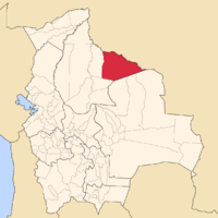
|map_caption = Map of Bolivia highlighting the province of Iténez |
|map_caption = Map of Bolivia highlighting the province of Iténez. |
||
|image_map1 = |
|image_map1 = Bolivia department of beni.png |
||
|mapsize1 = |
|mapsize1 = 250px |
||
|map_caption1 = |
|map_caption1 = Provinces of the Beni Department |
||
|pushpin_map = |
|pushpin_map = |
||
|pushpin_label_position = |
|pushpin_label_position = |
||
Revision as of 11:11, 17 August 2011
Iténez | |
|---|---|
Province | |
 Map of Bolivia highlighting the province of Iténez. | |
 Provinces of the Beni Department | |
| Country | |
| Departament | Beni |
| Settlements | |
| Area | |
• Total | 14,122 sq mi (36,576 km2) |
| Population (2006)[1] | |
• Total | 20,190 |
| • Density | 1.4/sq mi (0.55/km2) |
| Time zone | UTC-4 (GMT -4) |
Iténez is a province in the Beni Department, Bolivia.
References
13°30′00″S 63°19′59″W / 13.500°S 63.333°W

