Bolama region: Difference between revisions
Appearance
Content deleted Content added
m r2.7.1) (Robot: Adding no:Bolama (region) |
m r2.7.1) (Robot: Modifying eo:Regiono Bolama |
||
| Line 106: | Line 106: | ||
[[de:Bolama (Region)]] |
[[de:Bolama (Region)]] |
||
[[es:Región de Bolama]] |
[[es:Región de Bolama]] |
||
[[eo: |
[[eo:Regiono Bolama]] |
||
[[fr:Bolama-Bijagos]] |
[[fr:Bolama-Bijagos]] |
||
[[ko:볼라마 주]] |
[[ko:볼라마 주]] |
||
Revision as of 19:56, 11 January 2012
11°20′N 16°5′W / 11.333°N 16.083°W
Bolama | |
|---|---|
 Bolama Region | |
| Country | Guinea-Bissau |
| Seat | Bolama |
| Sectors | Bolama, Bubaque, Caravela |
| Area | |
• Total | 2,624 km2 (1,013 sq mi) |
| Population (2004) | |
• Total | 27,959 |
| • Density | 11/km2 (28/sq mi) |
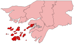
Bolama is an administrative region in Guinea-Bissau, consisting primarily of the Bijagós Archipelago of the country's southern coast, together with a small coastal strip centred on the coastal town of São João. It has an area of 2,624 km2. and a population estimated in 2004 at 27,959. Its capital is Bolama, on the island of the same name.
Subdivisions

Bolama is divided into 3 administrative sectors:
- Bolama, comprising the islands of Bolama and Galinhas, and some adjacent islands in the north-east of the region, together with the coastal strip.
- Bubaque, consisting of various islands including Bubaque, Orangozinho, Meneque, Orango, Soga, Rubane, Roxa and João Viera, all in the south of the Bijagós Archipelago.
- Caravela, consisting of various islands including Caravela, Carache, Uno, Unhacomo, Uracane, Enu, Formosa, Ponta and Maio, all in the north-west of the Bijagós Archipelago.
See also:
