Phipun district: Difference between revisions
m moved Amphoe Phipun to Phipun District |
m Robot - Speedily moving category Amphoe of Nakhon Si Thammarat to Category:Amphoe of Nakhon Si Thammarat Province per CFDS. |
||
| Line 86: | Line 86: | ||
{{DEFAULTSORT:Phipun}} |
{{DEFAULTSORT:Phipun}} |
||
[[Category:Amphoe of Nakhon Si Thammarat]] |
[[Category:Amphoe of Nakhon Si Thammarat Province]] |
||
Revision as of 09:41, 24 January 2012
Phipun
พิปูน | |
|---|---|
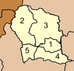
 Amphoe location in Nakhon Si Thammarat Province | |
| Country | |
| Province | Nakhon Si Thammarat |
| Seat | Phipun |
| Area | |
• Total | 363.8 km2 (140.5 sq mi) |
| Population (2005) | |
• Total | 27,578 |
| • Density | 75.8/km2 (196/sq mi) |
| Time zone | UTC+7 (THA) |
| Postal code | 80270 |
| Geocode | 8005 |
Phipun (Template:Lang-th) is a district (Amphoe) in the northern part of Nakhon Si Thammarat Province, southern Thailand.
Geography
Neighboring districts are (from the northeast clockwise) Nopphitam, Phrom Khiri, Lan Saka, Chawang of Nakhon Si Thammarat Province, Wiang Sa and Ban Na San of Surat Thani Province.
History
The minor district (King Amphoe) was created on September 1 1972, when the two tambon Phipun and Kathun were split off from Chawang district.[1] It was upgraded to a full district on September 8 1976.[2]
Administration
The district is subdivided into 5 subdistricts (tambon), which are further subdivided into 43 villages (muban). Phibun is a township (thesaban tambon) covering parts of the tambon Phibun. There are further 5 Tambon administrative organizations (TAO).
|

|
References
- ^ "ประกาศกระทรวงมหาดไทย เรื่อง แบ่งท้องที่อำเภอฉวาง จังหวัดนครศรีธรรมราช ตั้งเป็นกิ่งอำเภอพิปูน" (PDF). Royal Gazette (in Thai). 89 (130 ง): 2187. August 29 1972.
{{cite journal}}: Check date values in:|date=(help) - ^ "พระราชกฤษฎีกาตั้งอำเภอเลาขวัญ อำเภอคำม่วง อำเภอพิปูน อำเภอศรีเทพ อำเภอนาแห้ว อำเภอส่องดาว อำเภอควนกาหลง อำเภอค่ายบางระจัน อำเภอบ้านตาขุน และอำเภอกุดจับ พ.ศ. ๒๕๑๙" (PDF). Royal Gazette (in Thai). 93 (109 ก special): 31–34. September 8 1976.
{{cite journal}}: Check date values in:|date=(help)
External links
- amphoe.com (Thai)
- http://www.phipun.com Website of district (Thai)
