Tutuila: Difference between revisions
Appearance
Content deleted Content added
m spacing |
sp, slightly narrowing box so page is viewable in 600x800 format |
||
| Line 1: | Line 1: | ||
<!-- BEGIN WikiProject Mountains infobox (scroll down to edit main article text) --> |
<!-- BEGIN WikiProject Mountains infobox (scroll down to edit main article text) --> |
||
<!-- Use <nowiki>{{subst:Mountain_box_begin}}</nowiki> to get the next two lines --> |
<!-- Use <nowiki>{{subst:Mountain_box_begin}}</nowiki> to get the next two lines --> |
||
{| border="1" bgcolor="#ffffff" cellpadding="5" align="right" width=" |
{| border="1" bgcolor="#ffffff" cellpadding="5" align="right" width="250" style="margin-left:3px" |
||
!bgcolor=#e7dcc3 colspan=2|Tutuila |
!bgcolor=#e7dcc3 colspan=2|Tutuila |
||
|- |
|- |
||
|align=center colspan=2| [[Image:TutuilaFromSpace.jpg| |
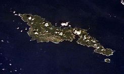
|align=center colspan=2| [[Image:TutuilaFromSpace.jpg|245px|Tutuila]]<br>Tutuila and Aunu‘u from the Space Shuttle. |
||
|- |
|- |
||
|bgcolor=#e7dcc3|[[Elevation]]:||653 m (2,142 feet) |
|bgcolor=#e7dcc3|[[Elevation]]:||653 m (2,142 feet) |
||
| Line 26: | Line 26: | ||
'''Tutuila''' is the main or largest [[island]] of [[American Samoa]], and the third largest island in the Samoan Island chain (see [[Samoa]]). The island is distinctive in the [[Pacific Ocean|Central Pacific]] for its large, natural harbor—Pago Pago Harbor—on which the capital of American Samoa, [[Pago Pago]], is located. |
'''Tutuila''' is the main or largest [[island]] of [[American Samoa]], and the third largest island in the Samoan Island chain (see [[Samoa]]). The island is distinctive in the [[Pacific Ocean|Central Pacific]] for its large, natural harbor—Pago Pago Harbor—on which the capital of American Samoa, [[Pago Pago]], is located. |
||
[[Image:Fatu Rock.jpg|left|300px|thumb|Fatu Rock (right) and Futi Rock (left), islets on the reef of Tutuila at the entrance to Pago Pago Harbor (behind Fatu)]] |
[[Image:Fatu Rock.jpg|left|300px|thumb|Fatu Rock (right) and Futi Rock (left), islets on the reef of Tutuila at the entrance to Pago Pago Harbor (behind Fatu)]] |
||
The area of the island is 135 square |
The area of the island is 135 square kilometers with an estimated population (1990) of 45,043. The highest point on the island is Matafao peak (653 m or 2142 ft). In the early [[19th century]], Tutuila was called ''Maouna''. |
||
<br clear="left"> |
<br clear="left"> |
||
Revision as of 21:03, 10 April 2006
| Tutuila | |
|---|---|
 Tutuila and Aunu‘u from the Space Shuttle. | |
| Elevation: | 653 m (2,142 feet) |
| Coordinates: | 14°17′42″S 170°42′00″W / 14.295°S 170.70°W |
| Location: | United States |
| Range: | Samoa Islands |
| Type: | Shield volcano |
| Last eruption: | Unknown |
| First ascent: | |
| Easiest route: | |
Tutuila is the main or largest island of American Samoa, and the third largest island in the Samoan Island chain (see Samoa). The island is distinctive in the Central Pacific for its large, natural harbor—Pago Pago Harbor—on which the capital of American Samoa, Pago Pago, is located.

The area of the island is 135 square kilometers with an estimated population (1990) of 45,043. The highest point on the island is Matafao peak (653 m or 2142 ft). In the early 19th century, Tutuila was called Maouna.
References
- Siebert L, Simkin T (2002–present). Volcanoes of the World: an Illustrated Catalog of Holocene Volcanoes and their Eruptions. Smithsonian Institution, Global Volcanism Program Digital Information Series, GVP-3 (http://www.volcano.si.edu).
