Arrondissement of Saint-Pierre, Martinique: Difference between revisions
Appearance
Content deleted Content added
Luckas-bot (talk | contribs) m r2.7.1) (Robot: Adding cs:Arrondissement Saint-Pierre (Martinique) |
don't thumb infobox images - to display a caption, use the |map_caption= parameter |
||
| Line 13: | Line 13: | ||
| km²=210 |
| km²=210 |
||
| dens=112 |
| dens=112 |
||
| |
| image_map=Martinique arr saintpierre.PNG |
||
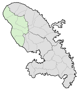
| map_caption=Location of Saint-Pierre in Martinique |
|||
}} |
}} |
||
Revision as of 20:46, 18 March 2012

Arrondissement of Saint-Pierre, Martinique | |
|---|---|
Settlement | |
 Location of Saint-Pierre in Martinique | |
| Country | France |
| Population (1999) | 23,464 |
The arrondissement of Saint-Pierre is an arrondissement of France, located in the Martinique département, in the Martinique région. It has 5 cantons and 8 communes.
Composition
Cantons
The cantons of the arrondissement of Saint-Pierre are:
Communes
The communes of the arrondissement of Saint-Pierre, and their INSEE codes, are:
| 1. Bellefontaine (97234) | 2. Le Carbet (97204) | 3. Case-Pilote (97205) | 4. Fonds-Saint-Denis (97208) |
| 5. Le Morne-Rouge (97218) | 6. Le Morne-Vert (97233) | 7. Le Prêcheur (97219) | 8. Saint-Pierre (97225) |
