Dolní Marklovice: Difference between revisions
Luckas-bot (talk | contribs) m robot Adding: pl:Marklowice Dolne |
.commonz |
||
| Line 1: | Line 1: | ||
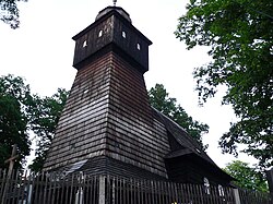
[[Image:Marklowice dolne-kosciol4.jpg|thumb| |
[[Image:Marklowice dolne-kosciol4.jpg|thumb|250px|Wooden church in the village]] |
||
{{Audio|Dolni Marklovice.ogg|'''Dolní Marklovice'''}} ([[Polish language|Polish]]: {{Audio-nohelp|Pl-Marklowice_Dolne.ogg|''Marklowice Dolne''}}) is a village in [[Karviná District]], [[Moravian-Silesian Region]], [[Czech Republic]]. It was a separate municipality but became administratively a part of [[Petrovice u Karviné]] in 1952. [[Petrůvka River]] flows through the village. |
{{Audio|Dolni Marklovice.ogg|'''Dolní Marklovice'''}} ([[Polish language|Polish]]: {{Audio-nohelp|Pl-Marklowice_Dolne.ogg|''Marklowice Dolne''}}) is a village in [[Karviná District]], [[Moravian-Silesian Region]], [[Czech Republic]]. It was a separate municipality but became administratively a part of [[Petrovice u Karviné]] in 1952. [[Petrůvka River]] flows through the village. |
||
| Line 5: | Line 5: | ||
'''Marklowice''' was a village in [[Cieszyn Silesia]], first mentioned in a written document in 1305, which split in the 17th century into the two parts, Marklowice Dolne and Marklowice Górne. They were joined together again at the end of the 19th century. After division of that area between [[Czechoslovakia]] and [[Poland]] in 1920, it was divided between these two countries. They were briefly reunited 1938-39 after Poland's annexation of [[Zaolzie]], although in two separate powiats of Cieszyn (Marklowice Górne) and Frysztat (Marklowice Dolne). Today's Dolní Marklovice is a western part of that village. Eastern part of the village is now known as [[Marklowice Górne]] and lies in Poland. |
'''Marklowice''' was a village in [[Cieszyn Silesia]], first mentioned in a written document in 1305, which split in the 17th century into the two parts, Marklowice Dolne and Marklowice Górne. They were joined together again at the end of the 19th century. After division of that area between [[Czechoslovakia]] and [[Poland]] in 1920, it was divided between these two countries. They were briefly reunited 1938-39 after Poland's annexation of [[Zaolzie]], although in two separate powiats of Cieszyn (Marklowice Górne) and Frysztat (Marklowice Dolne). Today's Dolní Marklovice is a western part of that village. Eastern part of the village is now known as [[Marklowice Górne]] and lies in Poland. |
||
The most important landmark of the village is a wooden [[Ascension of Jesus|Ascension of the Lord]] Church. First wooden church was built in 1360 and was consecrated to [[Saint Nicholas]]. New one was built in 1739 of [[larch]] wood and consecrated to the Ascension of the Lord. There is a [[Mother of God]] painting from 1860 in the church. It was painted by Polish painter and publicist Edward Świerkiewicz. Church is under permanent conservationist supervision and systematically conserved. There is a cemetery surrounding the church. The landmark had been |
The most important landmark of the village is a wooden [[Ascension of Jesus|Ascension of the Lord]] Church. First wooden church was built in 1360 and was consecrated to [[Saint Nicholas]]. New one was built in 1739 of [[larch]] wood and consecrated to the Ascension of the Lord. There is a [[Mother of God]] painting from 1860 in the church. It was painted by Polish painter and publicist Edward Świerkiewicz. Church is under permanent conservationist supervision and systematically conserved. There is a cemetery surrounding the church. The landmark had been depicted in the works of many artists like [[Franciszek Świder]], [[Rudolf Żebrok]] and Tadeusz Wratny. |
||
== People == |
|||
* [[Rudolf Paszek]], Polish teacher and politician |
|||
== See also == |
== See also == |
||
| Line 12: | Line 15: | ||
== References == |
== References == |
||
{{commonscat|Dolní Marklovice}} |
|||
* {{cite book |
* {{cite book |
||
| last = Londzin |
| last = Londzin |
||
Revision as of 10:36, 11 November 2012

ⓘ (Polish: ⓘ) is a village in Karviná District, Moravian-Silesian Region, Czech Republic. It was a separate municipality but became administratively a part of Petrovice u Karviné in 1952. Petrůvka River flows through the village.
Marklowice was a village in Cieszyn Silesia, first mentioned in a written document in 1305, which split in the 17th century into the two parts, Marklowice Dolne and Marklowice Górne. They were joined together again at the end of the 19th century. After division of that area between Czechoslovakia and Poland in 1920, it was divided between these two countries. They were briefly reunited 1938-39 after Poland's annexation of Zaolzie, although in two separate powiats of Cieszyn (Marklowice Górne) and Frysztat (Marklowice Dolne). Today's Dolní Marklovice is a western part of that village. Eastern part of the village is now known as Marklowice Górne and lies in Poland.
The most important landmark of the village is a wooden Ascension of the Lord Church. First wooden church was built in 1360 and was consecrated to Saint Nicholas. New one was built in 1739 of larch wood and consecrated to the Ascension of the Lord. There is a Mother of God painting from 1860 in the church. It was painted by Polish painter and publicist Edward Świerkiewicz. Church is under permanent conservationist supervision and systematically conserved. There is a cemetery surrounding the church. The landmark had been depicted in the works of many artists like Franciszek Świder, Rudolf Żebrok and Tadeusz Wratny.
People
- Rudolf Paszek, Polish teacher and politician
See also
References
- Londzin, Józef (1932). Kościoły drewniane na Śląsku Cieszyńskim. Cieszyn: Dziedzictwo błog. Jana Sarkandra. pp. 186–191. OCLC 297540848.
- Owczarzy, Władysław (2008). "Marklowicki kościółek". Zwrot: 20–21.
{{cite journal}}: Unknown parameter|month=ignored (help)
- Zahradnik, Stanisław (1991). Struktura narodowościowa Zaolzia na podstawie spisów ludności 1880-1991. Trzyniec: HT. OCLC 189422554.
- Template:Cs icon History of Marklovice
