Nevada State Route 119: Difference between revisions
Appearance
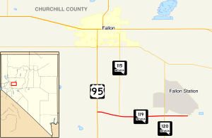
Route map:
Content deleted Content added
m r2.7.1) (Robot: Adding es:Ruta Estatal de Nevada 119 |
Add KML, jct table; link fix |
||
| Line 7: | Line 7: | ||
|length_mi=4.137 |
|length_mi=4.137 |
||
|length_round=3 |
|length_round=3 |
||
|length_ref=<ref name="state_maintained">[http://www.nevadadot.com/ |
|length_ref=<ref name="state_maintained">[http://www.nevadadot.com/About_NDOT/NDOT_Divisions/Planning/Roadway_Systems/State_Maintained_Highways,_Descriptions,_Index___Maps.aspx Nevada State Maintained Highways, Descriptions, Index and Maps]</ref> |
||
|established= |
|established=December 31, 1991 |
||
|decommissioned= |
|decommissioned= |
||
|direction_a=West |
|direction_a=West |
||
|terminus_a= |
|terminus_a={{jct|state=NV|US|95}} south of [[Fallon, Nevada|Fallon]] |
||
|junction= |
|junction= |
||
|direction_b=East |
|direction_b=East |
||
| Line 20: | Line 20: | ||
|next_route=120 |
|next_route=120 |
||
}} |
}} |
||
'''State Route 119''' is a [[state highway]] in [[Nevada]], [[USA]]. It connects [[U.S. Route 95 (Nevada)|U.S. Route 95]] east to [[NAS Fallon]] as part of |
'''State Route 119''' is a [[state highway]] in [[Nevada]], [[USA]]. It connects [[U.S. Route 95 (Nevada)|U.S. Route 95]] east to [[NAS Fallon]] as part of Berney Road. |
||
==Major intersections== |
|||
{{jcttop|state=NV|county=Churchill}} |
|||
{{jctint |
|||
|location=none |
|||
|mile=0.00 |
|||
|road={{jct|state=NV|US|95|city1=Fallon|city2=Hawthorne}} |
|||
}} |
|||
{{jctint |
|||
|location=none |
|||
|mile= |
|||
|road={{jct|state=NV|NV|115|dir1=North|name1=Harrigan Road}} |
|||
|notes=Southern terminus of NV 115 |
|||
}} |
|||
{{jctint |
|||
|location=none |
|||
|mile= |
|||
|road={{jct|state=NV|NV|120|dir1=south|name1=Pasture Road}} |
|||
|notes=Northern terminus of NV 120 |
|||
}} |
|||
{{jctint |
|||
|state=NV |
|||
|location=none |
|||
|mile=4.137 |
|||
|road=Beach Road |
|||
|notes=Gate to [[Naval Air Station Fallon|NAS Fallon]] |
|||
}} |
|||
{{jctbtm}} |
|||
==References== |
==References== |
||
{{AttachedKML|display=title,inline}} |
|||
{{Portal|Nevada}} |
{{Portal|Nevada}} |
||
{{Reflist}} |
{{Reflist}} |
||
Revision as of 14:27, 5 December 2012
| Berney Road | ||||
 | ||||
| Route information | ||||
| Maintained by NDOT | ||||
| Length | 4.137 mi[1] (6.658 km) | |||
| Existed | December 31, 1991–present | |||
| Major junctions | ||||
| West end | ||||
| East end | Beach Road in the southwest corner of NAS Fallon | |||
| Location | ||||
| Country | United States | |||
| State | Nevada | |||
| Highway system | ||||
| ||||
| ||||
State Route 119 is a state highway in Nevada, USA. It connects U.S. Route 95 east to NAS Fallon as part of Berney Road.
Major intersections
The entire route is in Churchill County.
| Location | mi | km | Destinations | Notes | |
|---|---|---|---|---|---|
| | 0.00 | 0.00 | |||
| | Southern terminus of NV 115 | ||||
| | Northern terminus of NV 120 | ||||
| | 4.137 | 6.658 | Beach Road | Gate to NAS Fallon | |
| 1.000 mi = 1.609 km; 1.000 km = 0.621 mi | |||||
References
KML is from Wikidata

