Moskva District, Kyrgyzstan: Difference between revisions
Appearance
Content deleted Content added
Thermokarst (talk | contribs) |
Thermokarst (talk | contribs) +population data |
||
| Line 55: | Line 55: | ||
|area_metro_km2 = |
|area_metro_km2 = |
||
|area_metro_sq_mi = |
|area_metro_sq_mi = |
||
|population_as_of = |
|population_as_of = 2009 |
||
|population_footnotes = <ref name=stat>{{Citation | last = | first = | author-link = | last2 = | first2 = | author2-link = | title = Population and Housing Census 2009. Book 3 (in tables). Provinces of Kyrgyzstan: Chuy Province (Перепись населения и жилищного фонда Кыргызской Республики 2009. Книга 3 (в таблицах). Регионы Кыргызстана: Чуйская область | place = Bishkek| publisher = National Committee on Statistics | origyear = | year =2010| month= | volume = | edition = | chapter = | chapterurl = | page = | pages = | url = http://212.42.101.100:8088/nacstat/sites/default/files/%D0%A7%D1%83%D0%B9%D1%81%D0%BA%D0%B0%D1%8F%20%D0%BE%D0%B1%D0%BB%D0%B0%D1%81%D1%82%D1%8C.pdf}}</ref> |
|||
|population_footnotes = |
|||
|population_note = |
|population_note = de facto population |
||
|population_total = |
|population_total = 83641 |
||
|population_density_km2 = |
|population_density_km2 = |
||
|population_density_sq_mi = |
|population_density_sq_mi = |
||
Revision as of 12:07, 25 January 2013
Moskovsky | |
|---|---|
 | |
 | |
| Country | Kyrgyzstan |
| Province | Chuy Province |
| Stalin District | 1930 |
| Population (2009)[1] | |
• Total | 83,641 |
| de facto population | |
| Time zone | UTC+5 (GMT +5) |
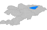
Moskovsky is a raion (district) of Chuy Province in northern Kyrgyzstan. The capital lies at Belovodskoye.[2]:
History
Moskovsky District was established as Stalin District on July 23, 1930. In 1961, it was renamed into Moskovsky District.
Towns, rural communities, and villages
In total, Moskovsky District includes 11 rural communities (aiyl okmotus). Each rural community can include one or several villages. The urban-type settlements, rural communities and villages in the Moskovsky District are[3]:
- Ak-Suu aiyl okmotu (center village Temen-Suu, and also villages Ak-Bashat, Ak-Torpok, Bala-Aiylchi, Keper-Aryk, Murake, and Chong-Aryk)
- Aleksandrovka aiyl okmotu (cener - village Aleksandrovka, and also villages Besh-Oryuk, and Krupskoe)
- Besh-Terek aiyl okmotu (center village Besh-Terek)
- Belovodskoye aiyl okmotu (cener - village Belovodskoye, and also village Kosh-Debe)
- Petrovka aiyl okmotu (center village Petrovka, and also villages Zavodskoe and Kyzyl-Tuu)
- Pervomay aiyl okmotu (cener - village Ak-Suu)
- Predtechenka aiyl okmotu (center village Predtechenka, and also village An-Aryk)
- Sadovsky aiyl okmotu (cener - village Sadovoe)
- Telek aiyl okmotu (center village Telek)
- Tselinny aiyl okmotu (cener - village Ak-Molo)
- Chapaev aiyl okmotu (center village Spartak, and also villages Ak-Seok, and Malovodnoe)
References
- ^ Population and Housing Census 2009. Book 3 (in tables). Provinces of Kyrgyzstan: Chuy Province (Перепись населения и жилищного фонда Кыргызской Республики 2009. Книга 3 (в таблицах). Регионы Кыргызстана: Чуйская область (PDF), Bishkek: National Committee on Statistics, 2010
{{citation}}: Cite has empty unknown parameters:|chapterurl=and|month=(help) - ^ Enrin.grida.no
- ^ List of Rural Communities of Kyrgyzstan

