Kajtasovo: Difference between revisions
Appearance
Content deleted Content added
category for deletion |
m Reverted edits by 187.115.86.98 (talk) to last version by 77.105.17.202 |
||
| Line 86: | Line 86: | ||
[[Category:Populated places in South Banat District]] |
[[Category:Populated places in South Banat District]] |
||
[[Category:Bela Crkva, Vojvodina]] |
[[Category:Bela Crkva, Vojvodina]] |
||
[[Category:Serb communities in Vojvodina]] |
|||
{{SouthBanatRS-geo-stub}} |
{{SouthBanatRS-geo-stub}} |
||
Revision as of 17:11, 9 February 2013
Kajtasovo
Кајтасово | |
|---|---|
Village | |
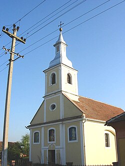
 The Orthodox church | |
| Country | |
| Time zone | UTC+1 (CET) |
| • Summer (DST) | UTC+2 (CEST) |
Kajtasovo (Serbian Cyrillic: Кајтасово) is a village in Serbia. It is situated in the Bela Crkva municipality, in the South Banat District, Vojvodina province. The village has a Serb ethnic majority and its population numbering 287 people (2002 census).
Historical population
- 1961: 494
- 1971: 459
- 1981: 424
- 1991: 350
- 2002: 287
References
- Slobodan Ćurčić, Broj stanovnika Vojvodine, Novi Sad, 1996.
See also
44°53′N 21°15′E / 44.883°N 21.250°E
Wikimedia Commons has media related to Kajtasovo.
