Nevelskoy Strait: Difference between revisions
Appearance
Content deleted Content added
necessary stress accent (from Russian Wikipedia) |
m Bot: Migrating 9 interwiki links, now provided by Wikidata on d:q715487 (Report Errors) |
||
| Line 13: | Line 13: | ||
[[Category:Straits of Russia]] |
[[Category:Straits of Russia]] |
||
[[Category:Sakhalin]] |
[[Category:Sakhalin]] |
||
[[et:Nevelskoi väin]] |
|||
[[es:Estrecho de Nevelskói]] |
|||
[[fr:Détroit de Nevelskoï]] |
|||
[[ja:ネヴェリスコイ海峡]] |
|||
[[nl:Straat Nevelskoj]] |
|||
[[pt:Estreito de Nevelskoy]] |
|||
[[ru:Пролив Невельского]] |
|||
[[uk:Протока Невельського]] |
|||
[[zh:涅韋爾斯科伊海峽]] |
|||
Revision as of 13:45, 26 February 2013
52°10′13″N 141°36′19″E / 52.17028°N 141.60528°E


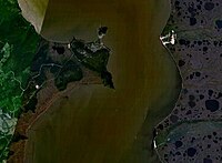
The Nevelskoy Strait (Template:Lang-ru) is a strait between Eurasia and Sakhalin that connects the main body of the Strait of Tartary with the Amur Liman (Amur River estuary). It was named in memory of Capt. Gennady Nevelskoy who in 1849 definitively established that the Strait of Tartary is connected with the Amur estuary and thus is in fact a strait, and not a gulf.
Length: 56 km, width (narrowest): 7.3 km, fairway depth: 7.2 m.
The strait was a place for the contemplated Sakhalin Tunnel.
