Meliadi: Difference between revisions
Appearance
Content deleted Content added
←Created page with '{{Infobox Greek Dimos |name = Meliadi |name_local = Μελιάδι |image_map = |map_caption = |periph = Central Macedonia |periphunit = Pieria (regi...' |
m Bot: Migrating 2 interwiki links, now provided by Wikidata on d:q3740094 |
||
| Line 37: | Line 37: | ||
[[Category:Populated places in Pieria (regional unit)]] |
[[Category:Populated places in Pieria (regional unit)]] |
||
[[bg:Мелиади (дем Катерини)]] |
|||
[[el:Μελιάδι Πιερίας]] |
|||
Revision as of 00:45, 23 March 2013
Meliadi
Μελιάδι | |
|---|---|
Settlement | |
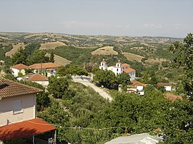
 A view of Meliadi | |
 | |
| Country | Greece |
| Administrative region | Central Macedonia |
| Regional unit | Pieria |
| Municipality | Katerini |
| Municipal unit | Elafina |
| Highest elevation | 370 m (1,210 ft) |
| Lowest elevation | 300 m (1,000 ft) |
| Population (2011)[1] | |
| • Rural | 103 |
| Time zone | UTC+2 (EET) |
| • Summer (DST) | UTC+3 (EEST) |
| Postal code | 601 00 |
| Area code(s) | +30-2351-xxx-xxx |
| Vehicle registration | KN |
Meliadi (Template:Lang-el) is a village and a part of the community of Lagorrachi.[2] Before the 2011 local government reform it was part of the municipality of Elafina.[2] The 2011 census recorded 103 inhabitants in the village.[1]
References
- ^ a b "Απογραφή Πληθυσμού - Κατοικιών 2011. ΜΟΝΙΜΟΣ Πληθυσμός" (in Greek). Hellenic Statistical Authority.
- ^ a b Kallikratis law Greece Ministry of Interior Template:El icon
