Krivogaštani Municipality: Difference between revisions
Appearance
Content deleted Content added
No edit summary |
m →References: WP:CHECKWIKI error fixes using AWB (8991) |
||
| Line 38: | Line 38: | ||
{{coord|41.35|N|21.34|E|source:itwiki_region:MK|display=title}} |
{{coord|41.35|N|21.34|E|source:itwiki_region:MK|display=title}} |
||
{{DEFAULTSORT:Municipality of Krivogastani}} |
|||
[[Category:Municipalities of the Republic of Macedonia]] |
[[Category:Municipalities of the Republic of Macedonia]] |
||
[[Category:Villages in Krivogaštani Municipality| ]] |
[[Category:Villages in Krivogaštani Municipality| ]] |
||
Revision as of 18:18, 29 March 2013
Municipality of Krivogaštani
Општина Кривогаштани | |
|---|---|
Municipality | |
 | |
| region | Pelagonia Statistical Region |
| Municipal seat | Krivogaštani |
| Population | |
• Total | 6,150 |
| Time zone | UTC+1 (CET) |
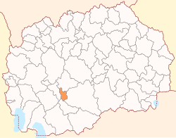
Krivogaštani (Template:Lang-mk) is a municipality in western Republic of Macedonia. Krivogaštani is also the name of the village where the municipal seat is found. This municipality is part of the Pelagonia Statistical Region.
Geography
The municipality borders Kruševo Municipality to the west, Dolneni Municipality to the north, Prilep Municipality to the east, and Mogila Municipality to the south.
Demographics
According to the last national census from 2002, the municipality has 6,150 inhabitants.[1]
Ethnic groups in the municipality include:
- Macedonians = 6,126 (99.6%)
- others = 24
Inhabited places
The main village of Krivogaštani is located along the main route from Prilep to Kruševo. The villages within this municipality include Bela Crkva, Obršani, Vođani, Ruvci and Krušeani.
References
- ^ 2002 census results in English and Macedonian (PDF)


