Pizzo di Cassimoi: Difference between revisions
Appearance
Content deleted Content added
m Robot - Speedily moving category Alpine Three-thousanders to Category:Alpine three-thousanders per CFDS. |
m Position on map |
||
| Line 23: | Line 23: | ||
A glacier named ''Vadrecc di Sorda'' lies over the northern flanks below a secondary summit (Pizzo Cassinello, 3,103 metres) on the side of Ticino. |
A glacier named ''Vadrecc di Sorda'' lies over the northern flanks below a secondary summit (Pizzo Cassinello, 3,103 metres) on the side of Ticino. |
||
Position on map [http://map.geo.admin.ch/?crosshair=circle&zoom=5&Y=721080&X=154350 http://map.geo.admin.ch/] |
|||
==References== |
==References== |
||
Revision as of 22:23, 25 April 2013
| Pizzo di Cassimoi | |
|---|---|
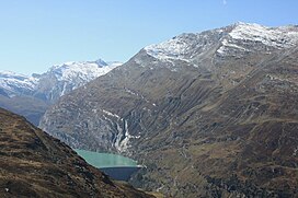
 Pizzo di Cassimoi (far left) from above Zervreilasee | |
| Highest point | |
| Elevation | 3,129 m (10,266 ft) |
| Prominence | 242 m (794 ft)[1] |
| Parent peak | Rheinwaldhorn |
| Geography | |
Lua error in Module:Location_map at line 526: Unable to find the specified location map definition: "Module:Location map/data/Switzerland relief" does not exist.
| |
| Location | Ticino/Graubünden, Switzerland |
| Region | CH |
| Parent range | Lepontine Alps |
Pizzo di Cassimoi is a mountain of the Lepontine Alps, located on the border between the Swiss cantons of Ticino (west) and Graubünden (east). The mountain overlooks two lakes: Lago di Luzzone on its north-eastern side and Zervreilasee on its north-eastern side.
A glacier named Vadrecc di Sorda lies over the northern flanks below a secondary summit (Pizzo Cassinello, 3,103 metres) on the side of Ticino.
Position on map http://map.geo.admin.ch/
