Central Lawrenceville: Difference between revisions
Appearance
Content deleted Content added
No edit summary |
No edit summary |
||
| Line 100: | Line 100: | ||
{{Pittsburgh}} |
{{Pittsburgh}} |
||
{{Allegheny County, Pennsylvania}} |
|||
[[Category:Neighborhoods in Pittsburgh, Pennsylvania]] |
[[Category:Neighborhoods in Pittsburgh, Pennsylvania]] |
||
[[Category:Economy of Pittsburgh, Pennsylvania]] |
[[Category:Economy of Pittsburgh, Pennsylvania]] |
||
Revision as of 16:30, 21 June 2013
Central Lawrenceville | |
|---|---|
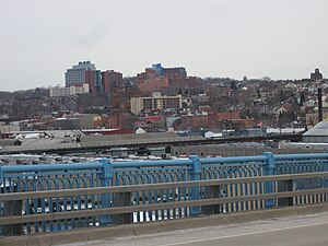
 Lower & Central Lawrenceville from the 31st Street Bridge. Children's Hospital is the dominant structure in the centre. | |
 | |
| Country | United States |
| State | Pennsylvania |
| County | Allegheny County |
| City | Pittsburgh |
| Area | |
• Total | 0.963 sq mi (2.49 km2) |
| Population (2000)[1] | |
• Total | 5,106 |
| • Density | 5,300/sq mi (2,000/km2) |
| ZIP Code | 15201 |
Central Lawrenceville is a neighborhood in the northeast of Pittsburgh, Pennsylvania in the United States. It has a zip code of 15201, and has representation on Pittsburgh City Council by the council member for District 7 (North Central East Neighborhoods). It is home to Allegheny Cemetery. Central Lawrenceville is the home of the Pittsburgh Bureau of Fire's 6 Engine and 6 Truck.
Surrounding and adjacent neighborhoods
Bloomfield, Garfield, Lower Lawrenceville, Millvale (via 40th St. Bridge), Upper Lawrenceville, Stanton Heights (all areas except Millvale are Pittsburgh city neighborhoods)
References
- ^ a b Template:Cite article Cite error: The named reference "pgh_census_2000" was defined multiple times with different content (see the help page).
Further reading
- Toker, Franklin (1986, 1994). Pittsburgh: An Urban Portrait. Pittsburgh: University of Pittsburgh Press. ISBN 0-8229-5434-6.
{{cite book}}: Check date values in:|year=(help)CS1 maint: year (link)

