Rituvík: Difference between revisions
Appearance
Content deleted Content added
m Bot: Migrating 9 interwiki links, now provided by Wikidata on d:q1194895 (Report Errors) |
No edit summary |
||
| Line 1: | Line 1: | ||
{{Infobox settlement |
|||
| ⚫ | |||
<!--See the Table at Infobox Settlement for all fields and descriptions of usage--> |
|||
| ⚫ | |||
<!-- Basic info ----------------> |
|||
|name = Rituvík |
|||
|other_name = |
|||
|native_name = <!-- for cities whose native name is not in English --> |
|||
|nickname = |
|||
|settlement_type = Village |
|||
|motto = |
|||
<!-- images and maps -----------> |
|||
|image_skyline = Rituvík, Faroe Islands.JPG |
|||
|imagesize = 250px |
|||
| ⚫ | |||
|image_flag = |
|||
|flag_size = |
|||
|image_seal = |
|||
|seal_size = |
|||
|image_shield = |
|||
|shield_size = |
|||
|image_map = |
|||
|mapsize = |
|||
|map_caption = |
|||
|pushpin_map = Faroe Islands <!-- the name of a location map as per http://en.wikipedia.org/wiki/Template:Location_map --> |
|||
|pushpin_label_position = right |
|||
|pushpin_mapsize = 250 |
|||
|pushpin_map_caption = Location in the Faroe Islands |
|||
<!-- Location ------------------> |
|||
|coordinates_display = inline,title |
|||
|coordinates_region = DK |
|||
|subdivision_type = State |
|||
|subdivision_name = {{flag|Kingdom of Denmark}} |
|||
|subdivision_type1 = Constituent country |
|||
|subdivision_name1 = {{flag|Faroe Islands}} |
|||
|subdivision_type2 = Island |
|||
|subdivision_name2 = [[Eysturoy]] |
|||
|subdivision_type3 = Municipality |
|||
|subdivision_name3 = [[Runavíkar kommuna]] |
|||
|<!-- Politics -----------------> |
|||
|government_footnotes = |
|||
|government_type = |
|||
|leader_title = |
|||
|leader_name = |
|||
|leader_title1 = <!-- for places with, say, both a mayor and a city manager --> |
|||
|leader_name1 = |
|||
|established_title = Founded <!-- Settled --> |
|||
|established_date = 1873 |
|||
<!-- Area ---------------------> |
|||
|area_magnitude = |
|||
|unit_pref =Imperial <!--Enter: Imperial, if Imperial (metric) is desired--> |
|||
|area_footnotes = |
|||
|area_total_km2 = <!-- ALL fields dealing with a measurements are subject to automatic unit conversion--> |
|||
|area_land_km2 = <!--See table @ Template:Infobox Settlement for details on automatic unit conversion--> |
|||
<!-- Population -----------------------> |
|||
|population_as_of = 1 January 2006 |
|||
|population_footnotes = |
|||
|population_note = |
|||
|population_total = 271 |
|||
|population_density_km2 = |
|||
|population_density_sq_mi = |
|||
|population_metro = |
|||
|population_density_metro_km2 = |
|||
|population_density_metro_sq_mi = |
|||
|population_blank1_title = |
|||
|population_blank1 = |
|||
|population_density_blank1_km2 = |
|||
|population_density_blank1_sq_mi = |
|||
<!-- General information ---------------> |
|||
|timezone = [[Greenwich Mean Time|GMT]] |
|||
|utc_offset = |
|||
|timezone_DST = [[European Summer Time|EST]] |
|||
|utc_offset_DST = +1 |
|||
|latd=62|latm=6|lats=25 |latNS=N |
|||
|longd=6|longm=40|longs=58|longEW=W |
|||
|elevation_footnotes = <!--for references: use <ref> </ref> tags--> |
|||
|elevation_m = |
|||
|elevation_ft = |
|||
<!-- Area/postal codes & others --------> |
|||
|postal_code_type = Postal code <!-- enter ZIP code, Postcode, Post code, Postal code... --> |
|||
|postal_code = FO 256 |
|||
|area_code = |
|||
|blank_name = |
|||
|blank_info = |
|||
|blank1_name = |
|||
|blank1_info = |
|||
|website = |
|||
|footnotes = |
|||
}} |
|||
'''Rituvík''' is a village on the southeast side of the Faroese island of [[Eysturoy]] located in the municipality of Runavíkar. |
|||
==History== |
|||
| ⚫ | Founded in 1873, its current church was built in 1855. The name Rituvík means ''Kittiwake Cove''.<ref name="stamps">{{cite book|first=Don|last=Brandt|title=More Stamps and Story of the Faroe Islands|url=http://www.faroestamps.fo/download/stamps_i_england-22.pdf|format=pdf|accessdate=2008-09-04|volume=1|origyear=2006|publisher=Postverk Føroya|location=Tórshavn|isbn=99918-3-191-6|page=35}}</ref> |
||
==Population== |
|||
The 2002 population was 256. Its postal code is FO 640 and it had a Post Office for the three years 1964-1967.<ref name="stamps" /> |
The 2002 population was 256. Its postal code is FO 640 and it had a Post Office for the three years 1964-1967.<ref name="stamps" /> |
||
| Line 11: | Line 102: | ||
{{commons|Rituvík}} |
{{commons|Rituvík}} |
||
{{coord|62|06|33|N|6|40|56|W|region:FO_type:city_source:dewiki|display=title}} |
|||
[[Category:Populated places in the Faroe Islands]] |
[[Category:Populated places in the Faroe Islands]] |
||
Revision as of 21:40, 9 September 2013
Rituvík | |
|---|---|
Village | |
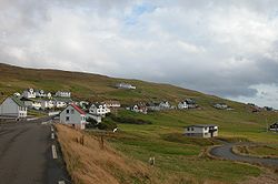
 Rituvík in Eysturoy, Faroe Islands | |
| State | |
| Constituent country | |
| Island | Eysturoy |
| Municipality | Runavíkar kommuna |
| Founded | 1873 |
| Population (1 January 2006) | |
• Total | 271 |
| Time zone | GMT |
| • Summer (DST) | UTC+1 (EST) |
| Postal code | FO 256 |
Rituvík is a village on the southeast side of the Faroese island of Eysturoy located in the municipality of Runavíkar.
History
Founded in 1873, its current church was built in 1855. The name Rituvík means Kittiwake Cove.[1]
Population
The 2002 population was 256. Its postal code is FO 640 and it had a Post Office for the three years 1964-1967.[1]
References
- ^ a b Brandt, Don. More Stamps and Story of the Faroe Islands (pdf). Vol. 1. Tórshavn: Postverk Føroya. p. 35. ISBN 99918-3-191-6. Retrieved 2008-09-04.
See also
Wikimedia Commons has media related to Rituvík.
